Make direct contact with the principal:
0419 353 414 or Elliott  0428 224 353
info@cromersurveyors.com.au

Glossary

A | B | C | D | E | F | G | H | I | J | K | L | M | N | O | P | R | S | T | U | V | W | Y | Z

Schedule 2

Schedule 2: of a Torrens title refers to the Easements, Fencing Conditions and any Crown Reservations and Conditions relating. The Crown Reservations and Conditions in a crown grant usually refer to the land being limited in depth to 15 metres and excluding all precious minerals, etc.

Schedule of Easements

glossary image: 

Schedule of Easements: means the primary conveyancing document in a sealed plan that sets out any easements, covenants or profits that are to created to benefit or burden the lots when the sealed plan takes effect.

The example on the right is a final Plan of Survey, showing Building Envelopes and Mutual Rights of Way, all of which are defined in the Schedule of Easements which is depicted underneath the Plan of Survey.

SIMPLY:

When a surveyor prepares a survey plan relating to a development for lodgement with Council he also prepares and organises two other documents. One is the Survey Notes and the other is the Schedule of Easements. This document reflects the old and new easements relating to the lots on the plan, together with any covenants. It needs to be endorsed by the owners and mortgagees. It can be simple in nature or complex where Rights of Way and the like are involved.

HOW WE ASSIST:

We can interpret this sometimes complex document for you and advise of those matters that affect the title in question.

Seal

Seal: The act of a Council finally approving a plan of survey and physically stamping it with a 'Seal', as in historical records.

Sealed Plan

Sealed plan (or SP, Final Plan or Plan of Survey): means a plan of subdivision or Survey approved by a local council (if necessary) and made effective by the Recorder of Titles. Also called a SP, A Final Plan of Survey or a Plan of Survey (not all Plans of Survey need approval by the local council, they can be prepared to support an application to convert a title description from a Sketch By Way of Illustration to a full Torrens Title). If a lodged plan complies with all aspects of a permit, then council accept it by placing their Seal upon it.

SIMPLY:

Means the plan that a surveyor prepares to finalise a subdivision which is then lodged with Council. Council ensure that the plan reflects the Permit conditions and 'Seals' such plan and forwards it to the Lands Titles Office for issue of new titles.

HOW WE ASSIST:

Surveyors are the only professionals allowed to prepare plans of subdivision. This office has the knowlegdge and experience to prepare such documents as required.

Search

Search: means, in a survey sense, the gathering of title and past survey information relating to a specific location.

SIMPLY:

It is the documentation that a surveyor needs to undertake his field survey and \or investigations. It is in excess of that gathered by solicitors, valuers and the like because it also includes the gathering of field notes. A Legal Search is not a Survey Search(but part thereof); any profession undertaking a search takes responsibility that they have obtained the most up to date information; hence Priority Notices and Unregistered Dealings. If part of an instruction Survey Search costs are normally in the order of $100 (Government Fee) with say $150 time involvement. The assessment of such search can run into $2-$300 or more. Even if a client possess what they believe to be search information it's value only extends to it being of assistance in initialising a new search.

Searches attract State Government fees on the basis of so much per title + so much per survey and are available through this office over the net.

HOW WE ASSIST:

You can purchase your Search Information and \or title through this office.

Sec 56 (LUPAA) Amendment

An application to Council for a s56 (LUPAA) minor amendment to a permit can be undertaken when a minor amendment to a Permit is sought.

A good example of the application of a Section 56 Amendment exists in relation to TasWater Permit conditions that require the Payment of a Headworks Charge as part of the Permit. The State Government has decided to remove the requirement for Headworks Charges in relation to TasWater and accordingly the subdivision Permits in existance must be Amended to remove this requirement. A section 56 application is the mechanism used to amend these permits.

Septic Tank

Septic Tank: is a means of effluent disposal that has been utilised for many years in unsewered areas.

In terms of development approval in unsewered areas, effluent disposal approval is necessary to achieve approval for the development.

SIMPLY:

Effluent disposal approval is a requirement of development approval in unsewed areas. It is therefore necessary to show that disposal is possible without failure within the boudaries of the lot to be approved and subject to a number of setback measures.

HOW WE ASSIST:

We are closely aligned with geotechnical experts who can provide the right advice concerning effluent disposal.

Contact us for advice in relation to these matters. 

Service Easement

glossary image: 

Service Easement: is an easement created to allow the legal right to lay and maintain drains, pipes, cables etc; it is a multi purpose easement: A Service Easement is added to the Final Survey Plan (see lot 5 adjoining) and is described in the Schedule of Easements as follows:

“SERVICE EASEMENT” means the full and free right and liberty for the proprietor of the dominant tenement, (NAME) Council, Tasmanian Water and Sewerage Corporation (Southern Region) Pty Limited, Telstra Corporation Limited, Aurora Energy Pty Ltd and the Crown its agents and contractors to enter upon the land marked "Right of Way (Private) & Service Easement 4.00 Wide on the plan to lay, inspect, maintain, repair and amend water mains, pipes, pumps, drains, mains, channels, gutters, sewers, wires, cables and other conducting media along and under the surface of the land, provided that the rights granted are exercised in a proper manner so as to cause as little inconvenience as possible and to do as little damage as practicable to the said land."

Servient Tenement

The party gaining the benefit of an easement is the dominant tenement, while the party granting the benefit or suffering the burden is the servient tenement.

Setback

Setback: is a term often associated with Planning Schemes and the like and usually relates to an offset that a new or proposed structure or boundary needs to be from a road, boundary, watercourse, industry or other designated structure

SIMPLY:

A specified distance from a feature to a proposed feature.

HOW WE ASSIST:

We can determine and inidcate on a plan the required offsets and their effect on a proposed development. 

Setout Survey

Setout Survey: Every proposed building should be properly set out in accordance with the architectural plans and specifications and reflects those plans only, not any additional regulations.

The architectual plans should also ensure compliance with boundary and easement set back ordinances as defined by same. If instructing firstly have a look at those links relating to Survey Fees, Terms of Contract and Survey Methodology. A request to Dial Before You Dig should also be made.

HOW WE ASSIST: We offer experience and a prompt service, liaising with either your builder or other allied professional as required. These set-out surveys often form part of a larger project, such as a strata title subdivision.

Contact us for advice in relation to these matters. 

Settlement

Settlement: Completion of a contract of sale of real estate at which time the buyer pays the money to the seller and seller provides the buyer with possession to the property. 

Settlement Date

Settlement Date: The date when the seller is paid the full purchase and ownership passes to the purchaser. 

Severance Titles

Severance Titles: Quite often the question is asked how a neighbour has been able to ‘subdivide’, whilst an adjoining owner has been refused approval. It may be that the adjoining owner has enjoyed the benefits of preparing ‘severance plans’ prior to 1995.

Historically the term “severance” was given to a block of land that could be excised from a larger title without the need for the boundaries to be surveyed, or for local council approval to be obtained.

In 1993 parliament enacted a suite of legislation to provide the state with a resource, management and planning system.

The Local Government (Building and Miscellaneous Provisions) Act 1993 was part of the legislative suite that, amongst other things, abolished severance titles.

The definition of “block” in the act still allows for the following part of land transfers, without the need for survey or council approval-

 The whole of a lot on a plan lodged with the Recorder of Titles before 1 January 1995
 The whole of an original crown grant
 The whole of the land in a title
 The whole of the land in a deed
 Part of the land in a title that can be verbally identified by description for transfer purposes

The act prohibits the part of land transfers of “severance blocks” that are-

 Intersected by a highway, railway, tramway or any other way
 Intersected by land of the crown, the commonwealth or other person
 A fragmented portion of a title that requires mathematical closure for description.

The severance moratorium expired on 1 January 1995 therefore only lots on plans lodged with the Recorder of Titles before that date can still be used to obtain part of land severance titles.

SIMPLY:

If a plan relating to severance lots was prepared and lodged with the Lands Titles Office prior to 1995, it is still possible to obtain separate titles without the need for Council approval or sometimes survey in the field.

HOW WE ASSIST:

We can determine the status of existing survey plans lodged at the Lands Titles Office and advise you accordingly.

Contact us for advice in relation to these matters. 

SIO Survey Information Only Plans

SIO Survey Information Only Plans: are a register of survey documents lodged at the Lands Titles Office (LTO) reflecting survey work undertaken by registered surveyors and include all Remark Surveys and some (at the surveyors discretion) Identification Surveys or similar surveys that locate survey data of possible future interest to the surveyor. If part of a Remark Instruction they can quite easily generate costs of $2500 or more. SIO Plan costs can typically run into $3-$5000 or more depending on the nature of the title. The Certificate that goes on the plan for such surveys alters to suit the circumstance of the survey.

They are NOT examined by the LTO and are a register only. They are searchable and form part of what one receives when undertaking a Survey Search. They can be used to assist further boundary definition.

Site Distance

Site Distance: relates to minimum prescribed distances from an access point onto road or highway to the point of first view of an approaching vehicle.

It is governed by standards such as height above the ground of the viewing point, distance from the edge of the road, elevation of the approaching or receding road and the speed limit on the highway.

SIMPLY:

A specified distance that relates to Australian Standards that defines a minimum distance required from an access point to the first view of an approaching vehicle.

HOW WE ASSIST:

We can advise, measure and map available site distances to satisfy the requirements of a council or appeal tribunal.

Sketch by Way of Illustration

glossary image: 

Sketch by way of illustration only: means that whilst the estates (ownership) in the title are guaranteed as correct; the boundaries are not derived from a registered survey. The boundary measurements on a sketch plan need to be interpreted in conjunction with any occupation (fences) or other boundary evidence that exists on the ground. 

In other words, means a description of land converted from a general law deed or conveyance where there was no survey data and where the deed was based on a verbal description only. Such titles do not support Strata Development and therefore need to be converted to Real Property Act title (or Torrens Title) by a surveyor undertaking a title survey and preparing a Plan of Survey.

Architects, Designers, Builders BEWARE:

Sketch By Way of Illustration: The Title Plan LOOKS like other Titles but it is based on non survey data and usually no field measurements. You CANNOT design structures using such titles. (indeed even Torrens Titles should be field checked prior to design). I have known cases of multi million dollar buildings being designed and construction commenced on such plans only to find that the measurements simply did not reflect the land available; and this by a large reputable Architectual firm.

NO Design and Construction  without a new field survey by a Registered Surveyor to determine boundarys. NO blind acceptance of boundaries derived from the digital data off the 'List'. Again such data LOOKS like the real thing but read the Disclaimer placed by the Government.

Tasmanian, in layman’s terms, 3 types of titles

·        

Torrens Title – The plan attached to these titles is based on field survey by registered surveyor

·        

Sketch by way of Illustration - Is not based on a field survey.

·        

Conveyance or deed – reasonably rare and usually a verbal description with no plan

Let’s Talk about Sketch By Way Of Illustration

The title for your site is based on a General Law Deed and the plan accompanying that title is a Sketch By Way Of Illustration Only Plan

This means that whilst the ownership shown on the title is guaranteed as correct, the boundaries may not be derived from a field survey

Therefore, the boundary measurements on such a sketch plan need to be interpreted in conjunction with any occupation (fences) or other boundary evidence that exists on the ground, meaning distances on the plan may not represent the distance on the ground. In the States of Australia Registered Land Surveyors are the only persons entrusted and Certified to deal with and make decisions relating to Boundary Definition.       

In this situation it is recommended that no design or construction take place without the benefit of a field boundary survey to accurately determine boundary locations.

Undertaking a boundary survey such as above negates concerns for all parties regarding the reliability of the dimension shown on the Sketch Title Plan and all gain the benefit of correct boundaries before proceeding into the design stage. Any deficiencies in title are highlighted sooner rather than later.

If a strata development is Proposed the Title needs conversion from a Sketch to a full surveyed title (ie a Torrens Title)

Strata is not possible on a Sketch By Way of Illustration title.

The conversion process includes lodging the resultant plan at the Lands Titles Office (LTO) for their examination and registration of the new title. Titles Office Fees are applicable to such registration, usually close to $1000. No Council approval is necessary.

You need to advise this office if a strata development is proposed on your site.

Many Detail and Contour Surveys are carried out by Engineering Surveyors and the like. Registered Surveyors are the only professionals licensed to deal with boundary matters in Tasmania.

If you have a Sketch By Way Of Illustration Title Plan you need a Registered Land Surveyor to determine boundary matters for you.


SIMPLY:

See the example adjoining. The plan 'looks' like every other title but the measurements and areas (if any) are a draftspersons interpretation (possibly of a conveyance) only. For many years there were two forms of title within Tasmania; General Law Deed (or conveyance) and Real Property Act title (or Torrens Title). Two main differences existed between the two; with General Law, there was a NEW deed or conveyance drawn up for each dealing and the land was described in a verbal manner (eg. easterly along Collins land to the creek etc). With Real Property Act title, there is one title, with each new dealing being registered on that document, together with a surveyed (and therefore survey plan) description of the land.

In recent times there has been a move to 'convert' general law land to Real Property Act title; This is mostly complete apart from the fact that the conversion only went as far as to create one document with the listed dealings; the description of the land remained as before, verbal as per a conveyance. To assist interpretation of this description, a sketch plan was created (a 'Sketch By Way of Illustration Only') by the Titles Office and attached to the title. The description of the land is therefore not supported by survey. 

Buyer beware!!!, an Identification Survey (check survey) should (must?) be undertaken prior to finalising a purchase of such a title (indeed any title). Similarily a Remark Survey should be undertaken if any form of construction is to take place.

Another document describes these titles as follows:

Over the past 30 years the Tasmanian government has progressively been converting general law deeds (or conveyances) to Torrens title as they are presented to the recorder of titles for registration (upon sale, mortgage, etc.)

The converted titles are made up of two parts; the schedules of ownership interests in the land and the plan of title.

Many old deed boundaries (or conveyance boundaries) were verbally described rather than being derived from a survey and consequently current legislation provides that the conversion plan prepared by the recorder of titles from a verbal description be a "sketch by way of illustration only".

Generally speaking this means that boundaries that follow lines of old & contented occupation may be a better representation of ownership than conversion plan measurements, subject to Boundary Redefinition Methodology.

There are "rules" in the boundary re-instatement process based on common, case & statute law; therefore the boundaries in a sketch plan can only be updated or amended by a new plan of survey that needs to be lodged with, and approved by, the recorder of titles.

Some old deed boundaries (or conveyance boundaries) are derived from actual survey and the recorder of titles gives the conversion of these deed boundaries the same status as torrens title surveys.

HOW WE ASSIST:

We can view the title and advise you of the likely need for a Identification (check) survey prior to purchase, as the available dimensions and area of such a block may not be consistent with the title documents. We can convert the title to allow Strata Development.

Slope

Slope: means the gradient, incline, rise, angle, slant or undulation of land. It is interpreted on plans by means of contours, shading or levels (RL's...Reduced Levels). It can be defined in % (10% is 1:10), angle (45 degrees is 1:1) or as a ratio (1:10...ie 1 unit in 10 units....say 1 metre in 10 metres)It is used in planning terms to define whether a portion of land is too steep for a particular type of development.

SIMPLY:

It is a measure of the steepness of land.

HOW WE ASSIST:

We can derive RL's (field levels) over land to derive slopes or contours to assist design of structures or satisfy Planning requirements.

Sole Agency

Sole Agency or Sole Listing Also called Exclusive Agency. One real estate company is appointed by the seller and is responsible for managing the marketing and sale of the home. All enquires must be conducted through the agent. Auction and tender are also forms of sole/exclusive agency. A sole or exclusive listing is usually for a specific period of time. 

Sole Listing

Sole Listing: or Sole Agency, also called Exclusive Agency. One real estate company is appointed by the seller and is responsible for managing the marketing and sale of the home. All enquires must be conducted through the agent. Auction and tender are also forms of sole/exclusive agency. A sole or exclusive listing is usually for a specific period of time. 

SPM or State Permanent Mark

SPM or State Permanent Mark

See also Map Grid of Australia (MGA)

The Survey Control Marks Database (SurCoM) contains positional, height and other information, relating to Survey Control Marks located at Survey Control Sites in Tasmania.

http://surcom.dpiw.tas.gov.au/surcom/jsp/login/index.jsp

from here you can

  • Search for information using a Mark or Site ID, or a defined area of interest;
  • Display and obtain Site Summaries for marks in a defined area of interest using LISTMap;
  • Download a Basic Mark Report that lists all of the Marks for which survey accurate coordinates and/or heights are currently available; or
  • View the SurCoM User Instructions.


Copyright The Geospatial Infrastructure Branch (GIB) - incorporating the Office of the Surveyor General - develops and implements policy, standards, systems and programs in the areas of cadastral survey, geodetic survey, spatial data and survey-related legislation. 

http://dpipwe.tas.gov.au/land-property-titles/geospatial-infrastructure-...

The Hobart City Council established similar marks within the city boundaries. Their MGA co-ords are found here (copyright Hobart City Council):

Stakeholder

Stakeholder: The Person who holds the deposit in connection with a sale, usually the vendor's agent, and is obliged to hold it on behalf of both parties. 

Stamp Duty

Stamp Duty

Is payable on some transactions such as Transfer of Easements. The following is an email conversation with an Officer of the State Revenue Office concerning the process for payment of Stamp Duty


I refer to our conversation earlier today in relation to the Smith/Brown transaction.  During this conversation I advised you:

1. The transfer that one had lodges must be dated for assessement by the State Revenue Office (SRO).

2. To enable the transfer to be assessed there are a number of additional forms that need to be completed and returned to the SRO with the dated transfer.

For your convenience I have included links to the documents that you need to lodge in relation to the Smith/Brown transaction.

• Transaction Information - Form - PDF   

https://www.sro.tas.gov.au/Documents/Duty-Transaction-Information-Form.pdf

To collect details about land transfers.  Some questions will not be relevant because of the type of transaction submitted for assessment

• Transferee (Purchaser) Information - Person - Form - PDF

https://www.sro.tas.gov.au/Documents/Duty-Transferee-%28Person%29-Inform...

To collect details about the transferee (Smith) of land if the transferee is a natural person (i.e. not a corporation). 

• Transferor (Vendor) Information - Person - Form - PDF

https://www.sro.tas.gov.au/Documents/Duty-Transferor-%28Person%29-Inform...

To collect details about the transferor (Brown) of land if the transferor is a natural person (i.e. not a corporation).

3. For the sake of completeness, and in anticipation of documents that you may need to lodge for assessment in the future, I have provided (below) a description of where you can obtain the full suite of lodgement forms you must complete when submitting documents to the SRO for assessment can be obtained from the State Revenue Office (SRO) Website.

• Go to the SRO Website (www.sro.tas.gov.au).

• Select “Duties” from the top menu and the select the “Forms” link.

• Open the section titled “Property Transfer Duties”

• Scroll down to the section headed “Transferees and Transferors” for links to lodgement forms you will need to send to the SRO along with the dutiable document you are lodging for assessment.


Regards


Stamp Duty

Stamp Duty: Payable to the Tasmanian Government on the transfer, it is assessed on the sale price of the property and is payable by the purchaser. Stamp duly is also payable on the mortgage document. 

State Level Datum to AHD

To convert a level datum from State Datum to AHD: (Australian Height Datum) subtract 0.165 metres from State Datum.

Statute

Statute: An Act of Parliament. 

Strata By-Laws

This Glossary Item on Strata matters also continues on 'page 2' of this Glossary listing as shown on the bottom of this page.

Strata By-Laws: in relation to a strata scheme mean the rules and regulations that each lot owner and occupier must observe for the orderly conduct and control of the strata scheme.

STRATA DISCUSSION IN GENERAL

STRATA IN GENERAL.

See https://www.legislation.tas.gov.au/view/html/inforce/current/act-1998-01...
In general terms the development of land is all about gaining separate titles to portions of real estate for separate dealings such as sale or finance generation.

There are two basic ways of achieving this goal, traditional subdivision or stratum development.

Traditional subdivision only relates to land and not buildings, whereas strata development relates to land and buildings (there are exceptions to this but generally land and structures are involved) and is three dimensional; i.e. strata titles also have a vertical description; they have depth and/or height!

Note the measurements on a Strata Plan are used for a different purpose than those on a traditional Survey Plan. See Measurements on Strata Plans to better understand these measurements.

The following comments are general in nature; each site has its own set of circumstances that may need resolving whether it be servicing, access, architectural etc.

We will not go into traditional subdivision here but aspects of this process are discussed in Subdivision Overview on this web site. Effectively traditional subdivision development involves the creation of titles that can stand alone in terms of services and legal and physical frontage. Councils place permit conditions on the developer to ensure that these separate services are provided by the developer so that the title is generally not reliant on other owners. Again there are exceptions to this but we are here to talk about Strata Development.

In a completed stratum (i.e. a development that has been constructed under a council permit to council standards, concrete drives, services etc), once one leaves the Council Public Road and enters the strata site the Council is not interested in what happens; any matters arising are the responsibility of the Body Corporate. It is like entering a new ‘town’ or closed community that is responsible for itself. The vehicle ways inside a stratum are not Public Roads but drives usually part of the common property.

So, one of the main attractions with a strata development is that they solve the need to create Public Road frontage for each individual title. Portions of open land capable of development but have limited frontage to a Public Road can generally be developed by strata development.

The other aspect that is attractive in a stratum is the lower standard of the provision of services such as access, water, stormwater and sewer (plus NBN, power and the like).

With traditional subdivision, a system of service mains (arteries) is constructed to a high standard and these services are then separated to each new title created. This is to ensure that no one title owner is reliant on another. As said this requires the creation of Service Mains that have a high-end construction standard that are taken over by the relevant service authority, but are constructed by the developer at their cost. These ‘Mains’ are designed by an engineer and created as a network of services and are subject to strict design controls and become the responsibility of the relevant service provider.

With a strata development, once one is inside the strata site and the services have been constructed by the developer, they become the responsibility of the Body Corporate. They can be constructed to ‘normal’ house connection standards; can pass through Body Corporate (common property) land or other owners land within the strata and are considerably cheaper to create. It should be noted that even the title survey is cheaper for stratums (is dependent on the number of floors and the ‘type’ of title; must be Torrens Titles or converted to Torrens Title).

Let’s digress for a moment. Pre the advent of strata we dealt with high rise ownership by creating companies and selling shares in that company. There are still some of these title arrangements in existence. They are harder to deal with and lending authorities have shown a reluctance to lend when they are involved. They can be converted to strata.

In early years of strata development, the title created was simply ‘along the face of’ the walls of the building and the rest of the ‘open’ land became common property. As time progressed the need to create separate portions (that were still part of the title) became apparent. Areas such as parking, gardens, outdoor sheds etc became part of the subject title, even if they were not ‘connected’ to the house proper. It is now possible, subject to other parameters being satisfied, to have 100% of the horizontal component of the subject land in individual ownership i.e., no horizontal common property.

A word on measurement and title description. Traditional subdivision requires that the land descriptions are defined by a Survey Plan and relating documents with Bearings & Distances shown on the Plan of Title. This renders them capable of redefinition and offers security of ownership. A strata title can use such methods but only needs to in rare complicated circumstances; a stratum uses the occupation of the physical structures to define the boundaries; it is sufficient to describe the strata title boundaries by using such terms as "The Horizontal Lot Boundaries are Shown by Heavy Unbroken Lines Defined by (for example): Site Boundarys, The Face of a Masonry Wall, The Centre of a Paling Fence XY, The Edge of a Concrete Drive, The Prolongation of the Wall AB, Measurements Where Boundaries Are Open, (Measurements In Brackets Are For Boundary Fixation Only)" etc

Because strata development was also created to deal with ownership over several levels or floors, the title documents have a vertical component to them. A simple stratum would define the horizontal boundaries using terms such as those in the paragraph above, and in addition describe the Vertical Boundaries as, "The Vertical Lot Boundaries Extend From One Metre Below Ground Level To Ten Metres Above Ground Level" or similar.

A more complicated development over several levels could use the terms, "Except The Hatched Portions Which Extend Vertically To The Centre Of The Ceilings Above" or "The Hatched Portion Is Over Two Floors", etc.

Each strata level (floor, level, layer of the cake, strata) is shown on a separate sheet of the Strata Plan and carries such terms as Ground Floor, First Floor, Second Floor etc and has a separate area measurement for each floor. Hence the total area of the title is the sum of all the floors plus the areas of the carports, open ground, gardens (all applicable to that title) etc.

The early stages of a stratum development are like a traditional subdivision. Whereas levels, contours, town planning and service research is required in both cases, the lodgement of a Development Application with Council differs for a Stratum.

Council will require plan documents that reflect (including but not restricted to) the floor layout of all the structures proposed plus elevations, driveway layout, parking, visitor parking, turning areas, private open space, degree of access to sunlight etc to be shown on the application. This means that a substantial cost component is required up front before submission to Council. Also, as mentioned above, the title must be Torrens Title or converted to such a title (by survey).

Further, Strata Titles relate to land plus bricks and mortar. They therefore must include the construction of at least two dwellings to completion before council will seal the strata plan and allow separate titles to be created and sold, creating cash flow.

A note on this aspect of the Strata Act. Councils have discretion on how they interpret this section. Some Councils will allow more vacant strata sites than others (Hobart City for example will allow one vacant site on a development of a minimum of three proposed titles).

Advice therefore needs to be gained from the relevant council concerning this provision. It is important for cash flow reasons. There are other methods of dealing with staging of strata’s that can be applicable to each individual site.

The staging aspect of the strata process sometimes ‘scares’ new developers but if one views the construction requirements for traditional subdivision there is very little difference in the cash flow requirements.

Further reading at https://www.legislation.tas.gov.au/view/html/inforce/current/act-1998-01... Strata Scheme & Master Plan, Disclosure Statement, Exclusive Use Strata By-LawsSketch By Way of Illustration, Strata Title; Amendment to a Strata Title, Strata By-Laws plus this page, STRATA DISCUSSION IN GENERAL

Also, see attached booklet prepared by DPIPWE for an overview of strata obligations.

Strata Scheme & Master Plan

This Glossary Item on Strata matters also continues on 'page 2' of this Glossary listing as shown on the bottom of this page.

Strata Scheme & Master Plan: means the complex of lots and common property, together with a system of administration and management, created upon the registration of a strata plan by the Recorder of Titles. If it is envisaged that the development is to take place in stages a Master Plan will be required. This sets out the Future Development of the site and is usually lodged with Council and the Titles Office with a Stage 1 Strata Plan. It gives purchasers and the developer security in terms of what is 'coming' in the remaining stages. A Disclosure Statement is also necessary to accompany the Master Plan plus an SDS form (See Below-Application for Registration of a Staged Strata Scheme). At the time of registering stage 1 it is also a good idea to prepare an ASO form (which is an Application By a Strata Lot owner to Amend a Strata Scheme) for future use when future stages are completed.

STAGED DEVELOPMENT SCHEME

GENERIC CRITICAL  FLOW PATH

(WHERE     EACH DEVELOPMENT        PROJECT  MAY REQUIRE   VARIATION)

    1. Make application to Council for a planning permit for the proposed

       development

    2. Develop  stage 1 in accordance with the permit conditions

    3. Prepare a master plan, disclosure statement & strata plan sheets and make

       application to Council for approval

    4. Prepare a scheme application and (together with the approved Council

       documents, any first by-law document & the certificate of title/s to the site)

       lodge with the Recorder of Titles for registration

    5. Establish the body corporate with a budget, insurance policy, bank account,

       etc. in accordance with the legislation

    6. Prepare document disclosure for marketing and sale purposes of the

       approved lots

    7. Any vacant development lots will need to be sold subject to the provisions of

       Part 3, Division 8 of the legislation

    8. Develop  further stage/s in accordance with the permit conditions

    9. Prepare amended strata plan sheets and make application to Council for

       approval

   10. Prepare an amendment application and (together with the approved Council

       amendment sheets & the certificate of title to the lot/s) lodge with the

       Recorder of Titles for registration

   11. Prepare document disclosure for marketing and sale purposes of the

       approved lots

   12. Continue the process until the scheme is ended

Strata Title Survey costs are dependent on the number of units AND the number of floors involved. In addition, if the title is a Sketch By Way of Illustration then a conversion survey to create a Torrens Title will be required, together with the necessary Lands Titles Office fees. With a Strata Survey, the surveyor certifies that the buildings are within the title boundaries; it may be necessary for the surveyor to undertake at the least an Identification Survey and quite possibly a Remark Survey to register his opinion of the boundaries and support his Strata Certificate. Have a look at Fees (Survey) for more information on Strata Title Surveys.

SIMPLY:

It means the structure of a subdivision undertaken by means of Strata Development. It involves the Lots (units) to be created, the land that may or may not be common property and the respective responsibilities (unit entitlements)of each lot owner, whether they be different or equal.

HOW WE ASSIST:

We can interpret the description of boundaries and unit entitlements that may apply to a strata development. Strata development is often undertaken to overcome a lack of sufficient frontage to allow traditional subdivision on a block of land.

Strata Title

This Glossary Item on Strata matters also continues on 'page 2' of this Glossary listing as shown on the bottom of this page.

Strata Title: A system of land title based on the horizontal subdivision of air space. In practice, plans of a building are registered, containing internal units marked as to their boundaries, and each allocated a tot number as in a plan of subdivision. The system is used to provide a certificate of title for each unit within a residential, commercial or factory building. 

Strata Title Survey costs are dependent on the number of units AND the number of floors involved. In addition, if the title is a Sketch By Way of Illustration then a conversion survey to create a Torrens Title will be required, together with the necessary Lands Titles Office fees. With a Strata Survey, the surveyor certifies that the buildings are within the title boundaries; it may be necessary for the surveyor to undertake at the least an Identification Survey and quite possibly a Remark Survey to register his opinion of the boundaries and support his Strata Certificate. Have a look at Fees (Survey) for more information on Strata Title Surveys


Strata Plan Checklist

Source: Office of the Recorder of Titles


1. The strata scheme is over a "full" status folio, not a "sketch".

2. Site measurements accord with the plan of title measurements.

3. Site plan boundaries mirror the folio plan boundaries.

4. Plan of survey (re-definition) required to support site if a "sketch" folio or if site measurements do not accord with the folio plan.

5. Site plan shows all building offsets of less than 2.00 metres.

6. Site plan and all building and lot details are drawn to scale.

7. Sheet 1 title block and details are current and correct.

8. Site plan abuttal information is current and correct, including a connection to a road junction or similar for location purposes.

9. Name of scheme is an address in a city, town, suburb or locality, or a name approved by the Recorder of Titles.

10. Each strata level is adequately defined (basement, ground floor, etc.) on a separate sheet as per Land Titles OfficeCircular Memorandum No. 5 of 1998.

11. The vertical and horizontal boundaries of each lot are adequately defined (both written and graphically) as per Land Titles Office Circular Memorandum No 5 of 1998 and the Survey Requirements for Strata Plans prescribed by the Survey Directions Tasmania pursuant to the Surveyors Act 2002.

12. Lot areas are correctly shown on each detail sheet.

13. Each lot has a unit entitlement and units are totalled on the final sheet.

14. Council and surveyor's certificates are signed and dated.

15. Council declaration is required if building extends under or over a highway.

16. Name of the body corporate is shown on the plan.

17. Address for the service of notices is shown on the plan.

18. A specific annexure sheet is required if special unit entitlements are being created or if the body corporate is being divided.

Strata Title Management (Terrace)

glossary image: 

Terrace Strata Management is a locally owned and operated strata management firm specialising in new developments.

Their Words

Our ethos is centred on creating and nurturing great culture within the body corporates that we manage – we’ve experienced first-hand the sense of community that owners or their tenants enjoy when things are set up right from the outset. 


We’ve put together a package to make sure your development has it all.  We help you and the body corporate comply with the Strata Titles Act 1998, and to enhance the liveability of your development once it’s completed. We work with you throughout construction, and at settlement. We liaise with your real estate agent and prospective purchasers, and we provide the necessary requisition documentation at settlement. We prepare the proposed budget and call the first AGM with you as sole member of the body corporate so that we have everything in place for the new owners.


Ideally, you’d engage us before you start selling so that we can provide your purchasers with the proposed budget and by-laws. This shows your market that you’ve thought ahead about strata living and the well-being of your purchasers.


Your purchasers will get a clear understanding of their rights and obligations from the comprehensive set of by-laws, which bring together the relevant parts of the Act, the model by-laws, the council planning permit, and anything else that is specific to your development. They’ll be written by a land information consultant who’s had 30 years with the Land Titles Office dealing with disputes, so you can be sure that he knows how to prevent problems.


We are the first point of contact for anything that crops up, including repairs or maintenance on common property as well as within the units, and we are a neutral third party if ever there are issues between the residents. 


On behalf of the body corporate, we undertake the following activities to ensure compliance with the Act:


Accounting

-         

Setting up the bank account

-         

Keeping the financial records

-         

Preparing annual financial statements of income & expenditure

-         

Issuing notices for fees

-         

Paying invoices and insurance premiums

-         

Reconciling the bank account

Insurance

-         

Arranging the Strata Insurance through Insurance Solutions Tasmania Pty Ltd

-         

Arranging a building replacement valuation as required

-         

Lodging and managing insurance claims

-         

Providing certificates of currency upon request

Documentation

-         

Maintaining the roll of owners

-         

Maintaining the Register of the Body Corporate

-         

Recording of all correspondence

-         

Preparing and supervising the use of the common seal

-         

Keeping of records including minutes, budgets etc

Annual General Meeting

-         

Convening, attending and chairing the AGM

-         

Submitting a budget for consideration of the Body Corporate

-         

Recording and distributing the minutes

-         

Reporting our activities at the AGM

Maintenance & Guidance

-         

Arranging minor maintenance (up to $1,000) or repairs of body corporate property


-         

Assisting the body corporate in carrying out its obligations and in its decision making


More from Terrace

Thank you for your interest in what we offer, we’d love the opportunity to work with you.

As you may be aware, a body corporate is automatically created when a strata scheme is registered, even when there are only two lots, and the Strata Titles Act 1998 imposes obligations on you as the developer, and on the body corporate.  We offer a streamlined package to assist you in complying with the Act, and getting your body corporate set up properly from the outset.


What’s in it for you?

  • Maximise your profits – A strata scheme with a properly established and active body corporate is more appealing to purchasers, especially interstate and informed purchasers, which helps maximise profitability
  • Create a Lifestyle - Terrace creates a harmonious and cohesive culture within a body corporate from the outset and we encourage developers to “create a lifestyle” for their purchasers. Our process reduces the likelihood of disputes and assists our bodies corporate in keeping the development compliant with the Act, well maintained and liveable
  • Protect your investment – we arrange strata insurance as soon as your certificates of occupancy are issued.  Not only does this comply with the Act, it ensures that your finished development is properly protected.
  • Comply with the Act – The Strata Titles Act 1998 imposes obligations on you as the developer and on the body corporate.  We take on those obligations so you can focus on what you do best (see a summary below)
  • We’re the first point of contact – we are happy to talk to real estate agents and prospective purchasers about what’s in place, how strata works and what the costs are. We provide them with the necessary paperwork, and we liaise with solicitors at settlement.  After completion, we have an established process in place to handle defects
  • Deadlocks – even lot bodies corporate have an inherent risk of deadlocks, which makes it very difficult for decisions to be made.  As a neutral, impartial party, we can provide the pros and cons of the proposal to assist owners in reaching an agreement
  • We run the first AGM – as developer, you are required to call the first AGM as soon as possible. We run this with you as the sole member of the boy corporate to put things in place ready for settlement of the contracts
  • Requisitions – the conveyancing lawyers require requisition documentation for settlement of the contracts. We provide these immediately upon request to ensure settlements proceed on time.  Our fee for these is covered in our set up fee.


What is common property? Common property includes anything outside the lot boundaries such as common driveways and gardens.  It also includes service infrastructure such as cables, wires, pipes, sewers, drains, ducts, plant and equipment by which water, gas, electricity, sewerage, storm water drainage or telecommunications are provided.


What are the costs? We charge a set-up fee which covers the costs of tailored by-laws, and the requisition certificates issued for settlement of contracts and liaison with your real estate agent, prospective purchasers and the land surveyor.


The by-laws - we have these drafted by a consultant who worked in around the Land Titles Office for more than 50 years.  In our experience, these by-laws are the cornerstone of a cohesive and effective body corporate – they clearly set out each owner’s rights and obligations, and we can draw on them to address any issues that arise. They also allow us to conduct business electronically, so we can deal with issue as they arise rather than having to wait for a meeting.


When do you engage us? As soon as possible – we will get the by-laws drafted as soon as the planning permit is issued, so that you can provide them to your purchasers.  By investing the time and money to set things up ready for the body corporate, you create the culture of the body corporate and simplify life for the purchasers.


Once title is issued, we undertake everything required of you or the body corporate to comply with the Strata Titles Act 1998, including

  • Management of the strata insurance policy in conjunction with Insurance Solutions Tasmania Pty Ltd
  • Opening a body corporate bank account
  • Explaining and enforcing by-laws (which would include improper use of car parks, and parking issues)
  • Developing a budget for body corporate approval to cover the costs of complying with the Strata Titles Act 1998
  • Issuing levies
  • Paying bills
  • Facilitating the maintenance and improvement of common property including perimeter fencing
  • Convening, chairing and recording annual general meetings


Levies average out between $1,300 - $1,500 per unit per annum.  They can be paid monthly, quarterly or annually. Budgets include

  • Strata insurance
  • Management fee
  • Gardening of common property (optional but recommended)
  • Building maintenance (optional – unusual in the first few years)
  • Sinking fund for future capital maintenance of common property

Please visit www.terracestrata.com.au to learn more about what we do.

Strata Title; Amendment to a Strata Title

AMENDMENT TO A STRATA PLAN

A strata plan registered by the Recorder of Titles under the Strata Titles Act 1998 may only be amended in accordance with the legislation.

A strata plan identifies the name and address of the scheme and the site, the vertical and horizontal boundaries of each lot, the common property, the allocation of general unit entitlements and the nature and allocation of any special unit entitlements.

Generally speaking; an amendment to a strata plan may require-

  1. A unanimous resolution of all lot owners; or
  2. An ordinary (majority) resolution of lot owners; or
  3. The consent of the affected lot owner/s carrying out the amendment; and
  4. The approval of the local Council.


1. Unanimous resolution

A unanimous resolution of a body corporate is required-

  • To buy or sell common property
  • To re-allocate unit entitlements amongst lots (the approval of Council is not required)

2. Ordinary resolution

An ordinary (majority) resolution of the body corporate is required-

  • To change the by-laws (Council approval is not required and any scheme by-laws must permit such a change by ordinary resolution)
  • To develop or divide a lot that requires an adjustment of boundaries between a lot and the common property, but with no disturbance of other lot owner’s unit entitlements

3. Affected lot owners consent

Only the consent of the affected lot owner/s is required-

  • Where the amendment does not disturb the horizontal or vertical boundaries of a lot, or the common property, or the allocation of unit entitlements
  • Where an owner’s lot is being divided without disturbing the horizontal or vertical boundaries of the lot, or any other owner’s lot, or the common property, or any other lot owner’s unit entitlements
  • Where two lot owners exchange boundaries or unit entitlements without disturbing any other lot owner’s boundaries or unit entitlements
  • Where the amendment is in accordance with a staged development scheme or a community development scheme

Each amendment to a strata plan has its own unique circumstances which may include a planning permit, building works, building approvals, survey amendments, documentation preparation and various lot owners’ consent.


A lot owner should consider seeking professional advice to negotiate their way through the process, as the above dot points are only a general guide.

Stratum

This Glossary Item on Strata matters also continues on 'page 2' of this Glossary listing as shown on the bottom of this page.

Stratum: Stratum means a part of land consisting of a space or layer below, on, or above the surface of land, or partly below and partly above the surface of the land, defined by reference to improvements or otherwise. Strata is the plural of stratum. 

In Simple Terms, Read

Further reading at 

Strata Scheme & Master Plan,   

Disclosure Statement,      

Sketch By Way of Illustration,     

Strata Title; Amendment to a Strata Title, 

Strata By-Laws,   

Measurements on Strata Plans 

plus this page, STRATA DISCUSSION IN GENERAL

Note some of these Headings are on Sheet (2) under "S" in this Glossary.

Sub-minimum Lot

Sub-minimum Lot: means a block of land that does not have the minimum measurements, shape, area or other provisions to comply with the requirements of a planning scheme.

SIMPLY:

There are many Planning Schemes in existence that have different minimum lot requirements. A lot that does not comply in one scheme may comply in another.

HOW WE ASSIST:

We can advise of minimum lot requirements in the location of your choice.

Subdivision Overview

glossary image: 

Please Write a Review if you feel this page has been of assistance.

Subdivisions can only be undertaken by Authorised Registered Surveyors. We employ such surveyors to undertake this type of Survey.

This document attempts to cover MOST subdivision eventualities. The process therefore appears onerous. It does not necessarily follow the complete path setout below. You have the choice of dealing with certain matters yourself with or without our guidance, or if you so desire, we can handle the whole matter on your behalf.

If you are invisaging being absent through this process, and documents such as the Schedule of Easements need signing, please ensure you organise a Power of Attorney (your solicitor maybe) to sign on your behalf in your absence. (Power of Attorney is a legal arrangement where a person (the donor) appoints one or more people (the donee/s) to conduct and manage the donor’s affairs. The power may be given for a specific task, or a defined period in time, or it may be for all purposes and for all time. The document must be registered with the Recorder of Titles before conveyancing documents can be executed by a donee on behalf of a donor. A donor may end the arrangement by revoking the appointment.)

Firstly, have a look at these links relating to Survey Fees, Terms of Contract and Survey Methology. When you make your first contact, we will give general advice without making any enquires unless simple. We will be keen to undertake what searches we can over the net with cost and give general advice with the assistance of this search. If you require zoning advice and discussions with Councils we then seek to recover our time and costs from here on in, including the Search cost. Consultants fees are applicable.

We will look at the subdivision process in general and zero in on various aspects for further clarification. Note that simple single lot subdivisions may not generate some or all of the issues raised below; however some will! What follows therefore is general in nature; in some cases an issue arises that needs special attention and clarification. The text in “quotation” marks & italics is taken from our standard documents forwarded to clients at the time of lodging an application with Council & to solicitors requesting the Schedule of Easements. It is inserted to highlight various aspects of the process. Those subdivisions not requiring Council Approval (a Council permit) will be dealt with later in this brief.


Subdivision Process in Brief.


A subdivision requiring Council Approval (a Council permit) tracks the following general path: Also see the attached pdf below for a general spreadsheet of items that will be possible cost issues.

A

Search of Information: The surveyor takes responsibility for utilising the most up to date survey information. Therefore, whilst an owner with a copy of his title or survey information is of assistance in this process, the surveyor must still undertake his own Search of records. This generates a State Government cost that becomes part of time and costs accounted to the client. Search involving plans that are done by hand by Titles Office staff generate time costs accordingly. Occasionally search is required that involves a professional search which generates further costs. Council and other records may also be sought.

B

Discussions & Advice: It is essential to determine from the client ‘what are they trying to achieve’. This seems simple but it is important to know the subdivision envisaged is to: generate cash? reduce maintenance? better amenity? etc. Discussions are held with Council officers in an attempt to be fore-warned of most issues that may arise in the process. This information is then passed onto the client and a determination made whether to proceed with the application or not. Note at this point we are still ‘best guessing’; we will only really know the full issues once we lodge an official application.

Most applications larger than a small number of lots will involve the expertise of a Town Planner to assess what Planning Processes Relating to Developments need to be followed. At this time an assessment can be made (but not always; sometimes issues arise later within the process) whether there is a need to involve other consultants to deal with any specific issues. For example, due to a historical problem, any application within the City of Glenorchy must be accompanied by a Geo-technical Report. Any application proposing effluent disposal by means of any system other than a piped sewer, normally requires an independent effluent disposal report. Any application in a Bush Fire prone area will need a BAL Report (Building Attack Level-BAL-relating to Fire Risk).  We recommend that an application is lodged with Council with associated reports only relating to those topics that are clearly essential to allow assessment. Hence the comment below: 

“We advise that even though the proposal complies with Council’s planning for the area, approval is not automatic. Recent experience would indicate that Council’s might also need to be determining the effect on the amenity of the area of the development.

Such matters as overshadowing, useability of private open space, solar access, driveway location, vehicle movements and height and scale of the potential development may need to be considered. (Council could also ask for details of the extent and type of vegetation on proposed lots, details and a report on the landscape and scenic issues of the site, details of waterways on and within the immediate area, including water holes and dams, details of contours on the entire site, a longitudinal section and cross sections of any proposed road, compliance with fire requirements, method of creek or river crossings and the like). Having regards to these matters, we advise that we may receive a request from Council to provide additional information relating. We feel at this time that it is more cost effective to lodge the application without providing such additional information and await feedback from Council. Those areas we feel do need addressing now are detailed. If you wish to address the other matters at this time, would you please advise.”

“You need to be aware that Council does have the power to request a geo-technical assessment to ascertain whether geo-technical matters will affect the development. It is our experience that Council is unlikely to request such a report at this time, however, if you wish the likelihood of such a request to be clarified, you should provide this office with further instructions. If a report is required, you need to be aware that the results of that report may affect the final design and viability of the application.”

“As the application involves the assessment of the land for septic tank suitability, contact should be made at this time with Council’s Senior Environmental Health Surveyor to arrange a mutually acceptable time to meet on site for septic tank assessment. Would you please organise this matter as soon as possible or authorise the undersigned to arrange the assessment on your behalf. It should be noted that Telstra now holds individuals and companies financially liable for negligent and malicious damage caused to Australia’s network of underground cables. “Look Out Below. Dial 1100 Before You Dig” request applies.”


Recent Experience has indicated that there may be requests for Reports relating to: 

·        

Land capability (agricultural potential);

·        

Bushfire hazard assessment;

·        

Biodiversity assessment;

·        

Visual impact assessment;

·        

On-site waste disposal;

·        

Access;

·        

Impacts on adjoining Creeks and other waterways.

·        

Landslip and other Geo-technical issues. 

          (Reports are never cheaper than $2500+gst per report and quiet often more, depending on the unique features of the site)

i

C

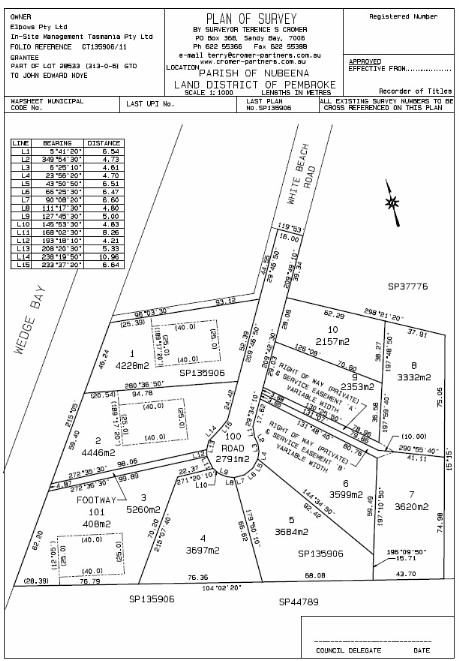
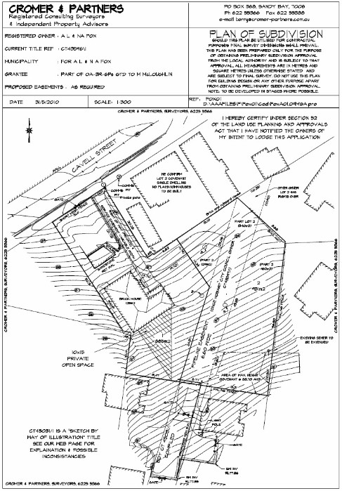
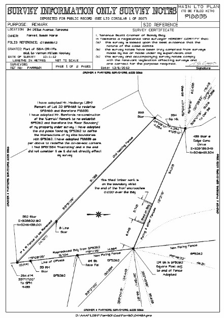
Plan of Subdivision OR Proposal Plan: The preparation of a ‘Subdivision Proposal Plan’. The top plan above is a "Plan of Subdivision" OR "Proposal Plan". Note that the preparation of this document may be achieved from: utilizing existing title, council, lands department or office records. However, more often than not it requires a degree of field work, a contour & detail survey, to determine (sometimes accuracy is necessary) locations of house, fences, services, engineering matters, contours and levels. This information is integrated with the above-mentioned title and other records. Note that this field work does not constitute the final title survey, although it may be of assistance at that later stage. Likewise, if a Detail Survey is required then it is often of substantial use later in the process, especially dealing with Permit conditions. As the method of gathering of field data is specific to it’s use, the Proposal Plan will also carry a disclaimer:

“The contours shown on this plan are taken from (the source is inserted here) and are suitable only for the purposes of this application. No reliance should be placed upon such contours other than for the purpose of this application for subdivisional approval. This plan may not be copied unless this note is included. Measurements and areas are subject to survey.”

“We request that you give consideration at this time to any additional rights or easements that you may think need to be created at the time of the final survey to allow full enjoyment of the allotments created. Such rights may relate to access, pipelines, Hydro lines, Telstra lines or drainage patterns or pipes.”

“As the application involves re-development of an existing serviced site, we advise that existing services running through the new lots to be created may need to be removed or easements created to cover same. Council will advise in relation to this matter.”

D

Lodgment of the Proposal Plan (Plan of Subdivision): The lodgment of the Proposal Plan and supporting documents with Council then follows. Most councils require assessment & advertising fees to accompany the application at this time, together with copies of title documents, any associated reports and a Development Application (DA). The DA includes a declaration by the surveyor that the owners of the land are aware of the application and agree with same, together with an authority to allow the general public to ‘look’ at the application documents within council. It is assumed by us that you agree to the above and have viewed our links relating to Survey Fees  & our Terms of Contract. Note also that if in a location where Sewer or water supply will be/is provided, TasWater will require an indicative report by an Engineer (or may be persuaded to accept a sketch plan by 'others, such as plumbers, contractors etc' that gives them the information they require) indicating the proposed services design and locations of same. This is required upon lodging the Proposal with Council or will form part of an RFI (Request for Further Information) that will immediately issue from TasWater upon Proposal lodging. If proposed services are within 2.00 metres of existing house footings further plans and cross-sections will be required.


Processing of Application: Council will advertise the application in the ‘local’ press and ask for submissions from any interested parties. The relevant State Act allows a processing time of 6 weeks within Council, within which time they can ask for additional information. The ‘clock’ stops until such information is supplied. We will contact you if such a request is made. Council officers then make a report to council (sometimes, if the application is minor and there are no representations, the officers have delegated power to deal with the matter without going to full council).

E

Permit (or Refusal): Following Council assessment a Permit or Refusal is issued. This permit has a life span of 2 years (may be extended at Council discretion) or must be “Substantially Commenced” within this time. You do not have to proceed with any permit. If for some reason you have two (or more) valid permits for the same parcel, you can choose which permit to exercise but once commenced on one, the others become invalid. Within the next 14 days Rights of Appeal apply as follows: note you have the same Appeal Rights if a Refusal is given or if you have concerns with any Permit Condition. See the note below:

Permit Conditions: This is a critical point in the subdivision process.  See attached pdf below for a general spreadsheet of possible cost issues.

All permit conditions must be completed before council will allow new titles to issue (THAT MEANS EVERY SINGLE CONDITION MUST BE TOTALLY SIGNED OFF TO THEIR SATISFACTION, NOT YOURS!). The Lands Titles Office is not the delay in the process or the Council, it is the subdividor thinking "that will do" in relation to Permit Conditions. The subdividor MUST get every condition signed off in writing that the Council is satisfied. Do not underestimate this process; this can hold you up for weeks, months or even years.

In some circumstances it is possible to lodge a Bond & Guarantee with Council to allow sealing of the survey plan. This process still requires the completion and approval of any engineering design involved, any additional reports required, all legal documents and the completion of the Final Field Survey, surveyors field notes and relating fees. Permit contributions, Headworks Charges , fees & charges must be attended to (in fact the only matters covered by the bond are construction matters). Bonds may be lodged part way through the construction process. Bond amounts are calculated on the outstanding construction cost plus a loading (usually around 25%).

If under a Permit a Part V Agreement is required to be entered into, then the permit does not take effect until the day the agreement is executed.

LUPAA defines ‘agreement’ as an agreement entered into under Part 5 of LUPAA.


The effect of these provisions is that a permit does not take effect until after any required Part 5 Agreements have been entered into. Any use or development undertaken in reliance on the permit prior to the Part 5 Agreement being executed may be in breach of the planning scheme.


See notes below re council charges; note all these matters may not be applicable to your development:

“Please be aware that the term ‘Council Fees’ within this document refers to those fees charged by Council to assess subdivision proposals. Other charges may be applicable resulting from the assessment of the proposal that form part of the subsequent permit. The developer\instructor is always responsible for all fees and charges generated by this development applied by Council and any other body.

We wish to draw to your attention at this time to the requirements relating to the provision of Public Open Space on proposal plans. Council has the power to refuse an application if no public open space is shown or if public open space as shown on a proposal plan is deemed to be inappropriate. They can also request a contribution in cash reflecting 5% of the value of the new lots created. Accordingly, you should contact the undersigned to discuss your options in relation to the provision of public open space at this time.

Some Council’s do charge a Final Sealing Fee to seal the final survey diagram. Unfortunately this fee is applicable in this Municipality and a cheque made out to Council amounting to $XXX.00 is required.

You will note that this development does not re-develop all of the lands in the titles involved. It is a requirement of the Land Titles Office that this office produce “Balance” plans relating to those portions of the titles not included in the development.

Land Titles Office fees applicable to developments are calculated on the basis of  a fee for a survey plan, plus a fee for every Lot, road lot, open space or other separately described parcel. Accordingly, would you please forward a cheque made out to the Lands Titles Office to cover this fee of $XXX.XX.”  See Fees of the Lands Titles Office

At the time of the issue of the Permit, we meet with the client and ‘go through’ all matters requiring attention before Council will Seal the Final Plan and allow the issue of new titles. Note the Lands Titles Office will only deal with a “Sealed Plan”. We then enter the field and undertake the Final Field Survey, undertake calculations, place survey marks and undertake all other survey matters required under the relevant Acts.

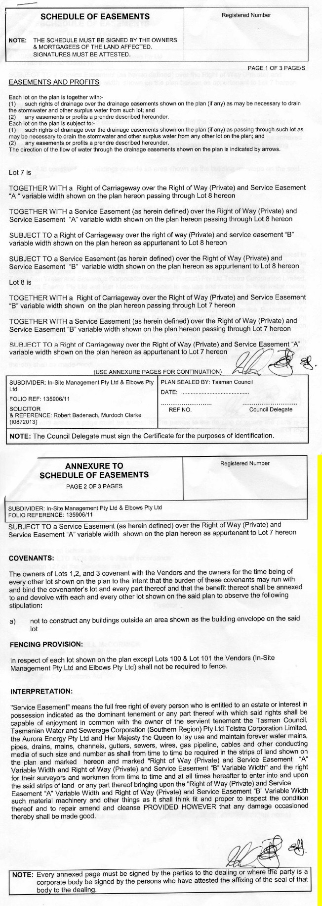
On completion of all Permit Conditions (or lodging of a bond if allowed) the surveyor gathers all outstanding documents ready for lodging both at the Lands Titles Office and the Council. This part of the process is tortuous as many matters must be dealt with, including but not restricted to the Schedule of Easements, the obtaining of a Production Slip, mortgage releases etc. The Schedule of Easements request made to the solicitor is usually in the following format and can include (but not always) matters as follows:

“We enclose a preliminary copy of our Plan of Survey (Final Plan) and request your perusal and comments in relation to same. Please note our Plan of Survey should not be acted upon until acceptance by the Land Titles Office and new titles issued. If our clients Architect, Engineer or similar consultant is to utilise a preliminary copy for design purposes they should be made aware of the above mentioned requirement for acceptance, as last minute amendments quite often occur.

We enclose a copy of Council’s Permit (Approval Letter) relating to this matter, together with a copy of our Plan of Subdivision (Proposal Plan) prepared to achieve the enclosed approval. We draw your attention to any Council requirements that need to be included in the Schedule of Easements and any other matters of a legal nature that, in your opinion, require your input and be of benefit to our mutual client. We consider it appropriate that the Schedule of Easements enclose a clause advising that the vendor be not required to fence.

Drainage Easements shown on our survey plan should be covered by the blanket clause within the Schedule, but if this is not the case, would you please take the appropriate action.

Wayleave Easements are to be created as indicated.

Cable Easements are to be created as indicated.

Pipeline Easements are to be created as indicated.

Existing rights shown on the Title documents are to be carried forward in total.

We refer you to mutual rights shown on our survey plan and confirm that the relevant allotments need to be subject to and together with such rights.

Would you please consult with our mutual client regarding any additional covenants or rights that they may require created within our survey and the Schedule of Easements and advise of any amendments to the survey diagram relating.

Please feel free to add notations to a copy of our survey diagram and return same to this office for amendment to the original so that such document reflects your Schedule of Easements.

You will note that Council require transfers to be endorsed and lodged with them in relation to all roads and public open space areas and that such transfers need to be produced prior to sealing of our final survey plan.

Service Easements are to be created as indicated.

You will note that our application is adhering portions together by means of Adhesion Order. At the same time of preparing the necessary Schedule of Easements, would you please prepare the relating Adhesion Order and return same to this office with the Schedule.

You will note that easements are to be amended as created by a previous sealed plan. It will be necessary to prepare a Petition to Amend relating to these easements and it would be appreciated if you could commence preparation of same.

You will note that a Parking Easement is envisaged for one or more of the lots shown on our plan. Your advice in relation to a suitable endorsement to be added to my plan is requested. It is appreciated that clarification may be necessary from the Lands Titles Office in relation to this matter.

When returning the Schedule of Easements, would you please enclose Production Slips relating to lodgment of all titles involved with the development at the Land Titles Office.

As the land in question is of General Law origin, we request you take into consideration the possibility of easements that may not be recorded in the original servient land, but were recorded in the deeds to the dominant land. We refer you to a recent case Parramore v. Duggan (1996) 70 ALJR 1.

We draw to your attention that easements are being created in favour of the balance lands. As the blanket clause within the Schedule does not cover parcels not shown as lots on our survey plan, it will be necessary for you to specifically refer to these easements within the main body of the Schedule.

You will note that a condition of Councils Approval is to enter into an agreement under Part 5 of the Land Use Planning & Approvals Act 1993. Registration of the agreement may take up to 2 months to finalise. Would you please prepare the necessary documentation to accommodate Council’s requirements as defined by Conditions of Approval.

Eaves Easements are to be created as indicated. Our previous experience with the interpretation of a eaves easement is as follows: "Easement of Eaves" means the right of the owners and occupiers for the time being of the dominant tenement to have eaves projecting or overhanging that portion of lot 'x' marked 'w''x''y''z' on the plan, and includes the right to enter in and upon the land for the purposes of repairing and maintaining such eaves at all times with or without workmen and making good any damage thereto occasioned by such entry in use.

Building Envelopes are to be created as indicated by the dashed lines on our plan.”

F

Costs: This question is the most difficult to answer, especially before a Permit is obtained and is still somewhat unknown before the Final Survey is commenced. When one considers the costs below, it is apparent that Survey Fees are but a small part of any subdivision cost, even a one lot subdivision.

Let us use the Council Development Application Fees (usually around $800) and the Lands Titles Office fees (usually around $1000) as a base unit (say $2000).

A simple permit condition of a street x-over could easily cost 3x this unit.

A water, sewer or stormwater connection could cost 1x this unit, for the break into the main alone, let alone the cost per metre of pipe to the development site itself.

A Manhole could cost 6x this unit.

Public Open Space Contribution could cost 10x and quiet easily more.

Survey Fees could cost 4x and upwards of this unit, depending on the type and complexity of the site. Please ensure that you have read our notes on Survey Fees, Boundary Redefinition & Survey Methodology via this link.

Engineering design costs could cost 3x and upwards of this unit.

Reports by other consultants could cost 2x and upwards.

Planning Appeals cost $50 to lodge and anywhere from 1x upwards for each consultant.

Council Headworks costs are normally in excess of 1x this unit per lot created.

Having said the above, once the extent of the application is known then a general ‘feeling’ of costs can be given (not including appeal costs).

Once a permit is granted, then costings can be estimated more accurately (subject to those comments within our notes on Survey Fees concerning Boundary Redefinition & Survey Methodology). 

G

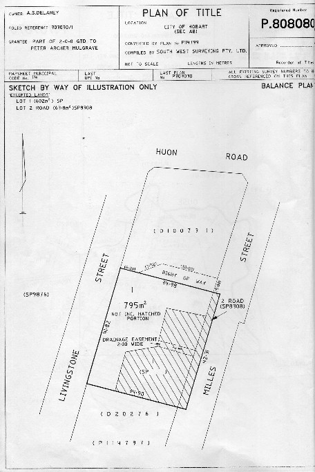
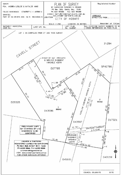
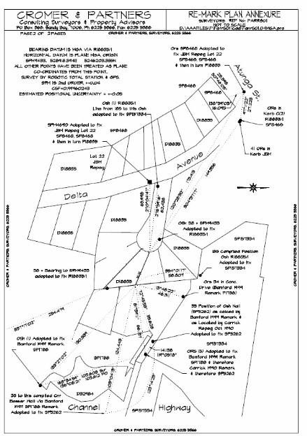
Plan of Survey, Plan Sealing & Titles: The completion of Permit Conditions and Survey Documentation allows the Survey Plan (Plan of Survey..see the second plan above and note that both plans reflect the same land, one prepared before Title Survey work and the other AFTER Title Survey field work) to proceed to Council & the Lands Titles Office for issue of new titles. Again the tortuous path here is ‘getting through’ the council and obtaining a Seal on the survey plan. All sections of Council must sign off on their own respective responsibilities, particularly planning, health & engineering. Further, the Water Authority (now TasWater) now play a big part in the Final Approval process, requiring a full As Constructed Survey of all new features + a plan relating. These regulations were upgraded in 2013 and have become quite onerous.  They will be especially interested in ensuring that all permit conditions have been satisfied. This is the last opportunity for Council to ensure compliance with Permit Conditions and the intent of the Permit. This need to ensure compliance with Permit conditions can involve (but not restricted to) the following list of matters, taken from two recent (August 2022) "Requests to Seal a Final Plan" lodged with the Clarence City Council. Please refer to this Glossary for any unknown terms.

8-8-22

LIST OF ESSENTIAL ITEMS:

WEED MANAGEMENT PLAN TO BE APPROVED + ROAD, STORMWATER, LOT ACCESS'S APPROVAL.

WEED MANAGEMENT PLAN MUST CARRY A BREAKDOWN OF COSTS.

TO SEAL THE FINAL PLAN A BOND OF 1.5 TIMES THE ESTIMATED COST OF WORKS OF IMPLEMENTING PLAN

FEES TO COUNCIL FOR APPROVING PLANS

CASH IN LIEU OF POS REQUIRED X%. (NORMALLY 5%). ADVICE TO COUNCIL RE POS ON TWO STAGES?

AS CONSTRUCTED

LOT ? TO HAVE 4.0 SEALED ACCESS + PASSING BAYS

AS CON ON POWER SUPPLY  +  WATER (IF WATER IS SUPPLIED)

ROAD WIDENING ALONG BACK XXXXX ROAD DONE 9.0 M FROM THE CENTRELINE OF EXISTING CARRIAGEWAY

BALANCE LOT TO STRADDLE ROAD TO XXXXXX ROAD

STAGE 2 TO BE SHOWN AS A SINGLE LOT

WORKS FOR ALL STAGES MUST BE COMMENCED WITHIN 2 YEARS OF THE DATE OF APPROVAL OR THE PLANS WILL NEED A NEW APPROVAL.

HAS TASWATER 'AUTHORITY TO SEAL' BEEN SIGNED AND ISSUED? (IF WATER IS SUPPLIED)

GUARANTEE LODGED RE ROAD MAINTAINANCE? (NORMALLY 5% OF CONSTRUCTION COST)

GUARANTEE LODGED RE FENCE COMPLETION

GUARANTEE LODGED RE ANY OUTSTANDING MATTERS

SCHEDULE OF EASEMENTS + TRANSFERS + DISCHARGES OF MORTGAGES……

ARE WE BUILDING A FENCE AROUND THE OUTSIDE BOUNDARIES

AS CONSTRUCTED COMPLETE + FLOW TEST

BANK GARANTEES RE OTHER MATTERS

DO WE NEED A PART V RE INCLUDE HAZARD MANAGEMENT ISSUES?

ANY MULTIUSER PATHWAYS ?? WIDE TO BE BUILT?

ANYTHING IN ADDITION TO BE DONE RE FIRE REPORT

A CLASS 3 WALKING TRACK THRU ALL POS REQUIRED?

APPROVAL WILL LAPSE 2 YEARS FROM THE DATE OF THE PERMIT.

Once the plan is sealed it proceeds to the Titles Office and provided all the legals and survey information is available new titles will issue, in the name that the original title was held.

H

Other Forms of Subdivision: there are other forms of subdivision that exist that are not as common. Strata Subdivision is the most common, followed by the resurrection of old Grant Lots . These are tricky areas requiring expert individual advice. Please contact relating. 

Subdivision Process in Brief

Two types are applicable:

Subdivision with Reticulated Services (generally Residential).

Subdivision with Limited or no Services (generally Rural Residential or Rural)


Subdivision with Reticulated Services (generally Residential).

1.   Search of Titles and Subdivision Plans

2.   Discussions with Council

3.   Detail Survey of Site, location of existing Services

4.   Draft Design of current and future services by engineer for TasWater.

5.   Preparation of Proposal Planengineering, Landslip, geo-technical, BAL assessment, Flora & Fauna etc and lodgement of same. Council Fees.

6.   42 day waiting period whilst Council process.

7.   RFI possibility (request for more info, engineeringLandslipgeo-technicalBAL assessmentFlora & Fauna etc) halt to the 42 days

8.   Issue (hopefully) of Permit with Conditions, including TasWater conditions.

9.   Chance of Appeal by all/any parties for 14 days

10.  Decision to move forward involving additional Reports to reflect Permit (engineeringLandslipgeo-technicalBAL assessmentFlora & Fauna etc)

11.  Final Title Survey + setout of engineering details.

12.  Construction + tidy up

13.  As Constructed Survey

14.  Preparation of Legal documents, Schedule of Easements, bonds, Titles Office (LTO) fees, Council fees, lodging of original titles at the Titles Office (Resulting in a Production Slip that goes to the surveyor with the Schedule of Easements).

15.  NOTE ALL PERMIT CONDITIONS MUST BE COMPLETED

16.  Lodgement of all documents with Council and the Lands Titles Office with their respective fees + TasWater. (the documents are duplicated and travel in two directions, Council and the LTO)

17.  Await checking and sign off by all parties. (this is the slow part, usually at Council and TasWater)

18.  Sealing of the Final Plan and Docs, forwarding to the LTO and issue of title on accepted documents.Plan of Survey, Plan Sealing Titles: The completion of Permit Conditions and Survey Documentation allows the Survey Plan (Plan of Survey..see the second plan above and note that both plans reflect the same land, one prepared before Title Survey work and the other AFTER Title Survey field work) to proceed to Council & the Lands Titles Office for issue of new titles. Again the tortuous path here is ‘getting through’ the council and obtaining a Seal on the survey plan. All sections of Council must sign off on their own respective responsibilities, particularly planning, health & engineering. Further, the Water Authority (now TasWater) now play a big part in the Final Approval process, requiring a full As Constructed Survey of all new features + a plan relating. These regulations were upgraded in 2013 and have become quite onerous.  They will be especially interested in ensuring that all permit conditions have been satisfied. This is the last opportunity for Council to ensure compliance with Permit Conditions and the intent of the Permit. This need to ensure compliance with Permit conditions can involve (but not restricted to) the following list of matters, taken from two recent (August 2022) "Requests to Seal a Final Plan" lodged with the Clarence City Council. Please refer to this Glossary for any unknown terms.

8-8-22

LIST OF ESSENTIAL ITEMS:

WEED MANAGEMENT PLAN TO BE APPROVED + ROAD, STORMWATER, LOT ACCESS'S APPROVAL.

WEED MANAGEMENT PLAN MUST CARRY A BREAKDOWN OF COSTS.

TO SEAL THE FINAL PLAN A BOND OF 1.5 TIMES THE ESTIMATED COST OF WORKS OF IMPLEMENTING PLAN

FEES TO COUNCIL FOR APPROVING PLANS

CASH IN LIEU OF POS REQUIRED X%. (NORMALLY 5%). ADVICE TO COUNCIL RE POS ON TWO STAGES?

AS CONSTRUCTED

LOT ? TO HAVE 4.0 SEALED ACCESS + PASSING BAYS

AS CON ON POWER SUPPLY  +  WATER (IF WATER IS SUPPLIED)

ROAD WIDENING ALONG BACK XXXXX ROAD DONE 9.0 M FROM THE CENTRELINE OF EXISTING CARRIAGEWAY

BALANCE LOT TO STRADDLE ROAD TO XXXXXX ROAD

STAGE 2 TO BE SHOWN AS A SINGLE LOT

WORKS FOR ALL STAGES MUST BE COMMENCED WITHIN 2 YEARS OF THE DATE OF APPROVAL OR THE PLANS WILL NEED A NEW APPROVAL.

HAS TASWATER 'AUTHORITY TO SEAL' BEEN SIGNED AND ISSUED? (IF WATER IS SUPPLIED)

GUARANTEE LODGED RE ROAD MAINTAINANCE? (NORMALLY 5% OF CONSTRUCTION COST)

GUARANTEE LODGED RE FENCE COMPLETION

GUARANTEE LODGED RE ANY OUTSTANDING MATTERS

SCHEDULE OF EASEMENTS + TRANSFERS + DISCHARGES OF MORTGAGES……

ARE WE BUILDING A FENCE AROUND THE OUTSIDE BOUNDARIES

AS CONSTRUCTED COMPLETE + FLOW TEST

BANK GARANTEES RE OTHER MATTERS

DO WE NEED A PART V RE INCLUDE HAZARD MANAGEMENT ISSUES?

ANY MULTIUSER PATHWAYS ?? WIDE TO BE BUILT?

ANYTHING IN ADDITION TO BE DONE RE FIRE REPORT

A CLASS 3 WALKING TRACK THRU ALL POS REQUIRED?

APPROVAL WILL LAPSE 2 YEARS FROM THE DATE OF THE PERMIT.

Once the plan is sealed it proceeds to the Titles Office and provided all the legals and survey information is available new titles will issue, in the name that the original title was held.


Subdivision with Limited or no Services (generally rural residential or rural)

19.  Search of Titles and Subdivision Plans

20.  Discussions with Council

21.  Possible Detail Survey of Site or compilation of existing records, possible location of existing Services, usually water.

22.  Preparation of Proposal Plan + engineeringLandslipgeo-technicalBAL assessmentFlora & Fauna etc and lodgement of same. Pay Council Fees.

23.  42 day waiting period whilst Council process.

24.  RFI possibility (request for more info, halt to the 42 days)

25.  Issue (hopefully) of Permit with Conditions

26.  Chance of Appeal by all/any parties for 14 days

27.  Decision to move forward involving additional Reports to reflect Permit (engineeringLandslipgeo-technicalBAL assessmentFlora & Fauna etc)

28.  Final Title Survey + setout of engineering details if any.

29.  Construction + tidy up

30.  Preparation of Legal documents, Schedule of Easements, bonds, Titles Office (LTO) fees, Council fees, lodging of original titles at the Titles Office (Resulting in a Production Slip that goes to the surveyor with the Schedule of Easements).

31.  NOTE ALL PERMIT CONDITIONS MUST BE COMPLETED

32.  Lodgement of all documents with Council and the Lands Titles Office with their respective fees + TasWater. (the documents are duplicated and travel in two directions, Council and the LTO)

33.  Await checking and sign off by all parties. (this is the slow part, usually at Council and TasWater)

34.  Sealing of the Final Plan and Docs, forwarding to the LTO and issue of title on accepted documents. Plan of Survey, Plan Sealing Titles: The completion of Permit Conditions and Survey Documentation allows the Survey Plan (Plan of Survey..see the second plan above and note that both plans reflect the same land, one prepared before Title Survey work and the other AFTER Title Survey field work) to proceed to Council & the Lands Titles Office for issue of new titles. Again the tortuous path here is ‘getting through’ the council and obtaining a Seal on the survey plan. All sections of Council must sign off on their own respective responsibilities, particularly planning, health & engineering. Further, the Water Authority (now TasWater) now play a big part in the Final Approval process, requiring a full As Constructed Survey of all new features + a plan relating. These regulations were upgraded in 2013 and have become quite onerous.  They will be especially interested in ensuring that all permit conditions have been satisfied. This is the last opportunity for Council to ensure compliance with Permit Conditions and the intent of the Permit. This need to ensure compliance with Permit conditions can involve (but not restricted to) the following list of matters, taken from two recent (August 2022) "Requests to Seal a Final Plan" lodged with the Clarence City Council. Please refer to this Glossary for any unknown terms.

8-8-22

LIST OF ESSENTIAL ITEMS:

WEED MANAGEMENT PLAN TO BE APPROVED + ROAD, STORMWATER, LOT ACCESS'S APPROVAL.

WEED MANAGEMENT PLAN MUST CARRY A BREAKDOWN OF COSTS.

TO SEAL THE FINAL PLAN A BOND OF 1.5 TIMES THE ESTIMATED COST OF WORKS OF IMPLEMENTING PLAN

FEES TO COUNCIL FOR APPROVING PLANS

CASH IN LIEU OF POS REQUIRED X%. (NORMALLY 5%). ADVICE TO COUNCIL RE POS ON TWO STAGES?

AS CONSTRUCTED

LOT ? TO HAVE 4.0 SEALED ACCESS + PASSING BAYS

AS CON ON POWER SUPPLY  +  WATER (IF WATER SUPPLIED)

ROAD WIDENING ALONG BACK XXXXX ROAD DONE 9.0 M FROM THE CENTRELINE OF EXISTING CARRIAGEWAY

BALANCE LOT TO STRADDLE ROAD TO XXXXXX ROAD

STAGE 2 TO BE SHOWN AS A SINGLE LOT

WORKS FOR ALL STAGES MUST BE COMMENCED WITHIN 2 YEARS OF THE DATE OF APPROVAL OR THE PLANS WILL NEED A NEW APPROVAL.

HAS TASWATER 'AUTHORITY TO SEAL' BEEN SIGNED AND ISSUED? (IF WATER IS SUPPLIED)

GUARANTEE LODGED RE ROAD MAINTAINANCE? (NORMALLY 5% OF CONSTRUCTION COST)

GUARANTEE LODGED RE FENCE COMPLETION

GUARANTEE LODGED RE ANY OUTSTANDING MATTERS

SCHEDULE OF EASEMENTS + TRANSFERS + DISCHARGES OF MORTGAGES……

ARE WE BUILDING A FENCE AROUND THE OUTSIDE BOUNDARIES

AS CONSTRUCTED COMPLETE + FLOW TEST

BANK GARANTEES RE OTHER MATTERS

DO WE NEED A PART V RE INCLUDE HAZARD MANAGEMENT ISSUES?

ANY MULTIUSER PATHWAYS ?? WIDE TO BE BUILT?

ANYTHING IN ADDITION TO BE DONE RE FIRE REPORT

A CLASS 3 WALKING TRACK THRU ALL POS REQUIRED?

APPROVAL WILL LAPSE 2 YEARS FROM THE DATE OF THE PERMIT.

Once the plan is sealed it proceeds to the Titles Office and provided all the legals and survey information is available new titles will issue, in the name that the original title was held.

Subject to Finance

Subject to Finance: A condition usually inserted into a contract, usually for the benefit of the purchaser. This then makes the offer subject to the purchasers confirming that they have raised finance within a certain period of time. 

Substantial Commencement

Substantial Commencement: Is a term used by Councils to reflect whether a Permit is still valid. Permits last for 2 years generally but do extend provided there has been ‘Substantial Commencement’ of the Permit conditions. This usually means that in additional to survey and engineering work being done, actual construction must be commenced on the site.

SIMPLY:

It means that one must commence survey and engineering design no later than 18 months into the permit, depending on the size of the development.

HOW WE ASSIST:

We can advise a suitable time frame relating to your development  

Sum Insured

Sum Insured: An amount which represents the total liability payable under an insurance policy by the Insurance Company. 

Survey

Survey: The process in modern terms of undertaking measurements to derive 'x' & 'y' co-ordinates on Map Grid of Australia Datum to allow future redifinition of boundaries and easements relating to a specific parcel of land, followed by the preparation of a plan and surveyors field notes in accordance with the Land Surveyors By-Laws to depict the survey and the survey methodology.

Also known means the definition, redefinition, measuremnt, interpretation, marking or documentation of the geographic position, dimension, extent or relativity of points, lines and things on, above or below the surface of the earth, for any purpose authorised by any Act.

Survey of Land includes a survey of land undertaken to remark boundaries of land originally surveyed for the purpose authorised by any Act.

Survey has the meaning given by the Surveyors Act 2002.


SIMPLY: The 'mapping' of a parcel of land utilising modern equipment such as a Robotic Theodolie and differential GPS to measure the shape of a parcel of land and describe same utilising bearings, distances and co-ordinates, together with the relationship of referenced corners to physical features reporting types of occupations and ages, origin of survey marks found and survey methodology relating to how the surveyor arrived at his opinion of the boundaries relating.

Survey Marks

glossary image: 

Survey Marks: are those marks placed by a surveyor to help define the boundaries or corners of a nominated parcel of land. A surveyors field notes define those marks placed in the course of the survey. Corners are usually marked by white painted wooden pegs of dimension 80mm x 80mm by a length of 380mm. However, in some circumstances they can also be defined by ‘Spring Head’ nails (SHs) [see photo to the right], steel ‘star fence droppers’ (stars), steel ‘bridge spikes’ (spike or spk) or a rod or steel bar (bar). Generally if the need arises any method of marking is undertaken and the form noted in the field notes. Surveyors often use brightly coloured ‘flagging’ tape to help identify survey matters of significance, as shown around this SH Nail in OPost. The second picture shows a Black Steel Star at the base of a silver fence dropper; the black steel star is the survey mark.

To make matters more confusing, surveyors use the same type of marks as ‘arbitrary’ survey stations and reference marks. They have a definite relationship to the boundaries as defined in the surveyors field notes but without the surveyors ‘skill’ are of little use to the layperson. The trap is if they are mistaken for a boundary corner mark. Survey Marks are also placed as 'Control' for Detail and Engineering type surveys.

SIMPLY:

Any type of mark may have been used to define your boundary corner. Be aware that a mark found may be a reference mark and not a corner. Surveyors field notes define the mark used.

HOW WE ASSIST:

As surveyors we understand surveyors field notes and can help identify the marks placed to define your boundary corner.

Contact us for advice in relation to these matters. 

Survey Methodology

Survey Methodology: Historically, surveyors entered the field with pack horses, a cook, camp equipment, someone to look after the horses, 5 chainmen, some axemen and most likely a survey assistant or two. Field work represented 95% of the time involved and therefore the equivalent percentage in the final fee.

We have been gradually working towards a situation where now with such ‘tools’ as GPS (note not always the total solution) we spend 50% of the time in the field and the remainder in front of the computer. Boundary Surveys & solutions by GPS require very good preparation and uploading of resultant data to the GPS Data Recorder.

GPS is simply another, quicker way of measuring. It does not supply a magical solution to boundary issues but allows the surveyor to more quickly seek solutions in the field, if he\she is well prepared. His\her expertise is still required to form an opinion of the boundary entitlements in accordance with accepted practice (best available evidence).

Some regulations that come into play when boundaries are under survey are:

(A) The surveyor must form an opinion of the location of the end of a boundary line if attempting to place a mark along the boundary line (ie a line peg).

(B) The surveyor must connect into adjoining boundaries by their surveys or the best available evidence to ensure that adjoining properties maintain their entitlements.

(C) Best available evidence may mean, due to lack of information or evidence, that the surveyor must measure further afield to come to a ‘best’ opinion. Note that ‘further afield’ can mean either further ‘away’ in distance or further back in time and age of surveys to come to a considered opinion.

(D) Measurements are not necessarily what boundary definitions are about. A quote from A G Foxhall’s Handbook for Practising Land and Engineering Surveyors:

“In the absence of evidence to the contrary the following is the order in which different methods of definition should be adopted, subject to abnormal conditions:

(1) Natural features, such as rivers, cliffs etc. See our section on Ad Medium Filum.

(2) Original marking of grant boundaries, road surveys, alignment or resumption surveys.

(3) Monuments and abutments.

(4) Original marking of private surveys.

(5) Occupations.

(6) (Lastly, and least satisfactory and only to be adopted when the previous methods do not apply) measurement.

This order is not arbitrary,……”

Measurement is a ‘tool’ used by the surveyor to assist in forming his\her opinion of a boundary. Once he\she has formed an opinion the surveyor then must mark and reference his\her survey and provide appropriate measurements on a plan lodged with the Recorder of Titles. The need to undertake new survey measurements to a certain accuracy (as set down by legislation) and prepare a plan is to ensure that in future, the then surveyor can rely on those measurements and plan to assist in redefining the relevant boundaries.  

Given the above, it is appropriate to reflect on Survey Fees generated by the Surveyor in complying with his staturatory responsibilities.

Survey Fees are usually Time & Costs. (See also Terms of Contract under Glossary)

Estimates or costings given do not include GST or Lands Titles Office or Search Costs:

Fees are due and payable on rendering of the invoice or account to the client. Payment by Direct Transfer is preferred to

ANZ:   BSB  017 318   ACC: 282998103 : Account Terence Cromer Quote Your File No. or Invoice No.
 

BOUNDARY SURVEYS require the purchase of information (search) from the Lands Titles Office. Upon instruction, this information is purchased (over the net) and an account generated and sent to the client for immediate payment. Surveys that are lodged at the Lands Titles Office generate a fee as per 'Fees of the Lands Titles Office'.

SIO Survey Information Only Plans: are a register of survey documents lodged at the Lands Titles Office (LTO) reflecting survey work undertaken by registered surveyors and include all Remark Surveys and some (at the surveyors discretion) Identification Surveys or similar surveys that locate survey data of possible future interest to the surveyor. If part of a Remark Instruction they can quite easily generate costs of $500 or sometimes more. The Certificate that goes on the plan for such surveys alters to suit the circumstance of the survey.

They are NOT examined by the LTO and are a register only. They are searchable and form part of what one receives when undertaking a Survey Search. They can be used to assist further boundary definition.

Boundary Survey costs are directly related to:

1. The age and proximity of the most recent adjoining surveys and the survey marks that may or may not still exist. The older the most recent survey, the less likelihood that survey marks from that survey still exist. Unfortunately, the existence of such marks cannot be confirmed until the survey is under way.

In many cases there are NO marks left in the vicinity. This then requires the surveyor to survey to out lying corners to either find additional old marks OR to utilise other further afield evidence to satisfy himself the land that his client is entitled to. 

2. The slope of the land.

3. The extent and thickness of the vegetation. Note that surveys by GPS require reasonably clear access to the sky.

4. The proximity or otherwise of Map Grid of Australia (MGA) survey control marks. (we are now required by law to connect to such MGA control). These are red coloured ‘brass plaques’ placed at random throughout the state. 

5. All surveys that involve the placement of survey marks MUST be registered at the Lands Titles Office by means of the preparation of a Plan and lodging of same.

6. See notes above concerning Boundary Redefinition for reasons why estimates are sometimes exceeded & an explanation of why we do what we do!

Survey Notes

glossary image: 

Survey Notes: mean the details forming part of a plan that show the boundary evidence the land surveyor found on the ground, the method used and the survey marks placed to carry out and complete a survey for land title purposes.

SIMPLY:

When a surveyor undertakes a land survey he prepares field notes of his work and how he has formed his opinion of the boundaries. These notes are registered at the Lands Titles Office for future use by others (just as we today are utilising the field notes of those before us). They need to be of sufficient drafting standard to be scanned and carry such clarity that no ambiguity exists. They are also mathematically checked by the surveyor before lodgement and in most cases checked again at the Lands Titles Office. It is for this reason that a surveyors responsibility does not end in the field; there is for office work to be undertaken to register his work.

HOW WE ASSIST:

Field Notes or Survey Notes are usually NOT drawn to scale. They are sketch notes and indicate bearings and distances. The bearings are rarely magnetic and the distances can be, depending on the age of the notes, in links & chains, feet and decimal feet or metres. We can interpret fieldnotes if required to assist you with understanding your title.