F.I.R.B. (Foreign Investment Review Board)
F.I.R.B. (Foreign Investment Review Board): A Commonwealth Government organisation that provides guidelines for the approval of purchase of Australian property by those who are not Australian citizens.
Tasmanian Surveying Consultants
Make direct contact with the principal:
0419 353 414, terry@tscsur.com.au or
Elliott on 0428 224 353, info@cromersurveyors.com.au
F.I.R.B. (Foreign Investment Review Board)F.I.R.B. (Foreign Investment Review Board): A Commonwealth Government organisation that provides guidelines for the approval of purchase of Australian property by those who are not Australian citizens. |
Fee (Agents)Fee: The fee or commission for selling the home payable by the seller to the real estate company. |
Fee simpleFee simple: means a freehold estate with an entire and absolute interest in the land and is the closest thing to absolute ownership that common law feudalism allows. ie. Freehold or Fee simple Owners of property have a fee simple or freehold estate, which is the highest form of ownership and is for an unlimited duration. An owner can use the land in any way desired, subject to the usual environmental, building, zoning. mining and other controls established by Government. |
Fees (Survey)glossary image: 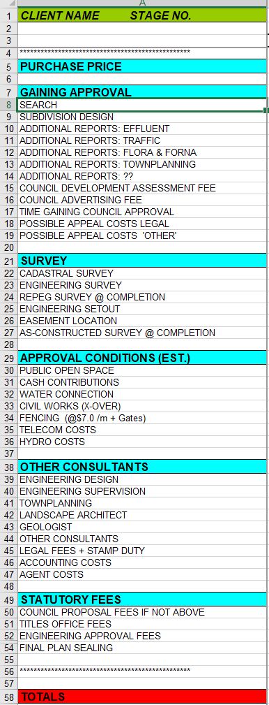 IF ASKED TO DO SO BY THIS OFFICE, YOUR SIGNATURE AND DATE OF SIGNING SIGNIFIES YOUR ACCEPTANCE OF THESE TERMS FOR OUR COSTING PURPOSES
SIGNATURE.........................................DATE
Survey Fees are usually Time & Costs. (See also Terms of Contract under Glossary). With any non-fieldsurvey instructions fees will be time and costs. When making an initial enquiry the first basic questions costs are carried. If you then ask matters to be researched such as file history, likeliness of further approval, estimate of costs etc, then these times are booked to the job and rendered to you at the next applicable time. Subdivisions generate costs generally in accordance with the attached SubCosts.jpg to the right. Note any unintentional damage to underground services are the responsibility of the instructor. Dial Before You Dig requests should be made by the instructor if concerns are apparent re this clause. Surveys requiring Registration can only be undertaken by Authorised Registered Surveyors. We employ such surveyors to undertake this type of Survey. Estimates given do not include GST or Lands Titles Office or Search Costs: Estimates are just that, an estimate of the costs involved. It is difficult to be precise as the time involved is not apparent until on site. Some more recent boundary sites can have costs estimated to the point of being quotes. Please note there is no Boundary Survey that generates fees less than $2500 + gst, most titles created within the last 20 years would cost at least $2500 + gst but all Remark & Identification Surveys are subject to Survey Methodology and the rules of Boundary Re-establishment (see Survey Directions, 14-Sept 2018 and Boundaries and the List) which can result in substantial increase in fees. Older parent surveys, travel, slope and vegetation effect survey costs. Fees are derived from time and costs + {Search costs + time on Pre Field Calcs (see web page)} + gst where applicable. See also Fees Variation Surcharge. Fees are due and payable on rendering of the invoice or account to the client. Payment by Direct Transfer is preferred to ANZ: BSB 017 318 ACC: 282998103 : Account Terence Cromer Quote Your File No. or Invoice No.
Briefly, moreso in a residential area and all things being equal (*), whether the request is one boundary or four it makes very little difference, because one still needs to:
*Obviously if some corners or boundaries have increases in vegetation, slope or other physical restaints then further costs may apply. It should be noted that estimating survey costs with a view to negating the need to later amend the costing should involve the purchase of Survey Search, investigation of same and a site visit. Occasionally the Survey Search and availability of survey evidence makes a nonsense of the estimate and further discussions and arrangements are needed with the client. BOUNDARY SURVEYS require the purchase of information (search) from the Lands Titles Office. Upon instruction, this information is purchased (over the net) and is added to the costs of the project. See Additions to Fees. Surveys that are lodged at the Lands Titles Office generate a fee as per 'Fees of the Lands Titles Office'. Can only be undertaken by Authorised Registered Surveyors. We employ such surveyors to undertake this type of Survey. Boundary Survey costs are directly related to: 1. The age and proximity of the most recent adjoining surveys and the survey marks that may or may not still exist. The older the most recent survey, the less likelihood that survey marks from that survey still exist. Unfortunately, the existence of such marks cannot be confirmed until the survey is under way. In many cases there are NO marks left in the vicinity. This then requires the surveyor to survey to out lying corners to either find additional old marks OR to utilise other further afield evidence to satisfy himself the land that his client is entitled to. Please also read Boundary Redefinition Methodology here or below. 2. The slope of the land. 3. The extent and thickness of the vegetation. Note that surveys by GPS require reasonably clear access to the sky. See Fees Variation Surcharge. 4. The proximity or otherwise of Map Grid of Australia (MGA) survey control marks. (we are required by law to connect to such MGA control). These are red coloured ‘brass plaques’ placed at random throughout the state. 5. All surveys that involve the placement of survey marks MUST be registered at the Lands Titles Office by means of the preparation of a Plan and lodging of same. 6. See notes below concerning Boundary Redefinition for reasons why estimates are sometimes exceeded & Survey Methodology for an explanation of why we do what we do! Another option (to possibly come up with a better estimate) is to spend some money now on a search of the survey information to determine the age of adjoining surveys + MGA locations etc. This information belongs to the client. Boundary Redefinition: The surveyor is responsible by State Legislation to ensure the integrity of the State Cadastre. He\she has delegated authority to undertake boundary definition within the State to a specified standard. Sometimes, within the course of a field survey, it becomes apparent that there is a problem or a particular aspect of his\her survey that requires further investigation and clarification. This may only be apparent once the surveyor enters the field to undertake his\her survey. Consequently, in some cases, estimates are exceeded in the course of the surveyor carrying out his\her resposibilities as described in the relevant Acts. We will always attempt to contact the client from the field to explain this situation if it arises and the reason for the increase in estimated fees. In some cases such increases can be quite onerous. Please Contact us if you have any queries in relation to this matter. Survey Methodology: Surveyors must comply with those matters listed in Check List for Surveyors. Historically, surveyors entered the field with pack horses, a cook, camp equipment, someone to look after the horses, 5 chainmen, some axemen and most likely a survey assistant or two. Field work represented 95% of the time involved and therefore the equivalent percentage in the final fee. We have been gradually working towards a situation where now with such ‘tools’ as GPS (note not always the total solution) we spend 50% of the time in the field and the remainder in front of the computer. Boundary Surveys & solutions by GPS require very good preparation and uploading of resultant data to the GPS Data Recorder. GPS is simply another, quicker way of measuring. It does not supply a magical solution to boundary issues but allows the surveyor to more quickly seek solutions in the field, if he\she is well prepared. His\her expertise is still required to form an opinion of the boundary entitlements in accordance with accepted practice (best available evidence). Some regulations that come into play when boundaries are under survey are: (A) The surveyor must form an opinion of the location of the end of a boundary line if attempting to place a mark along the boundary line (ie a line peg). (B) The surveyor must connect into to adjoining boundaries by their surveys or the best available evidence to ensure that adjoining properties maintain their entitlements. (C) Best available evidence may mean, due to lack of information or evidence, that the surveyor must measure further afield to come to a ‘best’ opinion. Note that ‘further afield’ can mean either further ‘away’ in distance or further back in time and age of surveys to come to a considered opinion. (D) Measurements are not necessarily what boundary definitions are about. A quote from A G Foxhall’s Handbook for Practising Land and Engineering Surveyors: “In the absence of evidence to the contrary the following is the order in which different methods of definition should be adopted, subject to abnormal conditions: (1) Natural features, such as rivers, cliffs etc. Note see our section on Ad Medium Filum. (2) Original marking of grant boundaries, road surveys, alignment or resumption surveys. (3) Monuments and abutments. (4) Original marking of private surveys. (5) Occupations. (6) (Lastly, and least satisfactory and only to be adopted when the previous methods do not apply) measurement. This order is not arbitrary,……” Measurement is a ‘tool’ used by the surveyor to assist in forming his\her opinion of a boundary. Once he\she has formed an opinion the surveyor then must mark and reference his\her survey and provide appropriate measurements on a plan lodged with the Recorder of Titles. The need to undertake new survey measurements to a certain accuracy (as set down by legislation) and prepare a plan is to ensure that in future, the then surveyor can rely on those measurements and plan to assist in redefining the relevant boundaries.
STRATA TITLE SURVEY and Strata Schemes & Master Plans costs are dependent on the number of units AND the number of floors involved (and the number of stages if a staged scheme). For general information on Strata Subdivision please read Strata Discussion in General (note when re-directed to the "S" section scroll down and click on page "2" to find Strata Discussion in General). In addition, if the title is a Sketch By Way of Illustration then a conversion survey to create a Torrens Title will be required, together with the necessary Lands Titles Office fees. With a Strata Survey, the surveyor certifies that the buildings are within the title boundaries; it may be necessary for the surveyor to undertake at the least an Identification Survey and quite possibly a Remark Survey to register his opinion of the boundaries and support his Strata Certificate. Strata Title Surveys require the purchase of information (search) from the Lands Titles Office. Upon instruction, this information is purchased (over the net) and an account generated and sent to the client for immediate payment. Strata Surveys are lodged at the Lands Titles Office and generate a fee as per 'Fees of the Lands Titles Office'. Can only be undertaken by Authorised Registered Surveyors. We employ such surveyors to undertake this type of Survey. YOUR SIGNATURE AND DATE OF SIGNING SIGNIFIES YOUR ACCEPTANCE OF THESE TERMS FOR OUR COSTING PURPOSES
SIGNATURE.........................................DATE |
Fees for Planning Applications at CouncilThis Page gives you a Link to Southern Tasmanian Local Government Planning Fees (ie Council Fees) Clarence City https://www.ccc.tas.gov.au/living/home-property/payments-rates-fees/#201... Hobart City See Below under HCC Sorell http://www.sorell.tas.gov.au/wp-content/uploads/2015/07/sorell_council_s... Central Highlands Council http://www.centralhighlands.qld.gov.au/wp-content/uploads/2016/01/regist... Kingborough https://www.kingborough.tas.gov.au/wp-content/uploads/2017/07/Fees-Charg... Glenorchy City See Below See Also the attached GCC Strata Application Process Form Brighton http://www.brighton.tas.gov.au/images/stories/PDFs/Other/Fees__Charges_-... Tasman http://www.tasman.tas.gov.au/download/planning-fees-2016-17.pdf Huon Valley http://www.huonvalley.tas.gov.au/payments/schedule-of-fees/ Derwent Valley Page 16 https://www.derwentvalley.tas.gov.au/webdata/resources/files/DVC%20Fees%20and%20Charges%20Register%202019%202020.pdf Glamorgan Spring Bay http://gsbc.tas.gov.au/wp-content/uploads/2017/07/Fees-and-Charges-2017.pdf |
Fees of the Lands Titles OfficeSUBJECT: Land Titles Office Statutory Fees – Fees applying from 1 July 2024 were recently gazetted
If you have any queries regarding the above please email titles.enquiries@dpipwe.tas.gov.au
THE OLD FILE RELATES TO FEES FOR JULY 2023 ONWARDS UNTIL JULY 2023 are attached
a new file relating to new fees applicable from July 1 2024 |
Fees Variation SurchargeFees Variation Surcharge: This Variation may be applied to fees when any of the following situations are encountered. See also Additions to Fees. When advising a client of the estimated costs relating to a survey the surveyor uses information given to him by the client or the clients agent to determine factors that will influence the time involved with such a survey. If due to misunderstanding or lack of knowledge the client or agent has not given a clear and accurate picture of a location then this Surcharge may be applied to keep things fair and reasonable to all parties. Quite often clients will request advice or research on matters that are outside of the initial instruction and quite often fall within the area of expertise practised by their Solicitor, Town Planner, BAL expert or Engineer. If advice can be given and being outside the initial instruction and not forming part of the Fees Estimate these costs therefore need to form part of the Fees Variation Surcharge. See Time & Costs Outside an Estimate. There is also another area where estimating runs into trouble. Just as the underwater Salvage Expert cannot determine what he is going to find when a vessel sinks, a surveyor cannot determine what matters will effect his survey until on site. Just as the plumber cannot determine how many metres of pipe are effected by roots, the surveyor cannot determine what evidence is still available until on site. Just as the surgeon cannot determine the extent of a cancer until he has explored, the surveyor cannot determine to what extent he must survey further afield than the immediate site. In all these cases we all use our experience to estimate what may be involved with an instruction; the surgeon does not stop his operation because he has exceded his estimate of what is involved. Sometimes one just needs to keep going. If a surveyor has placed some marks during his survey, he is required by law to go on and register those marks with the Lands Titles Office; ie complete his survey even if he has received an instruction to stop. Fees Variation Surcharge therefore applies. The following are examples that influence time and costs relating to surveys. Boundary & Identifcation Surveys: A project costs may be estimated on the basis of advice that the "site is all clear and of moderate slope etc". If a corner or corners subsequently are found to have vegetation in the form of trees, blackberries or similar then the time to mark that corner or corners becomes extensive and further costs should be applicable. It should be noted that vegetation outside the land holding can also influence costs as we are required to survey to the terminal point of a boundary line if it extends beyond the land under survey. Further, if a boundary survey has estimated costs based on the use of a GPS and it is found that indeed there exists debilitating vegetation rendering the use of the GPS impossible then a traditional 'theodolite & measure" survey is required at much increased time involvement. Even the presence of a single corner that has access issues can increase time and therefore costs substantially. If vegetation has subsequently regrown to an extent where the time involved with the survey is substantially in excess of that estimated then we reserve the right to charge an additional Surcharge for this additional time. The presence of tree cover not planned for in a survey can mean the difference between the use of GPS technology or the need to revert to traditional 'slash and traverse' with a theodolite to survey sites. The other situation that sometimes arises is when advice is given that the survey cost of one boundary approximates the cost for four; this is because the same 'process' must be gone through for one boundary as for four. It is not uncommon though that once the survey is underway and the instruction is extended and the remaining boundaries are 'looked at' that issues arise, whether they be the need to switch from GPS to 'traditional methods', "survey evidence" issues, vegetation or similar restricting matters. Fees Variation Surcharge will be applicable in these cases. A project costs may be estimated on the basis of advice that the "site is all clear and of moderate slope etc". Recent experience of such a statement indicated that the instructor failed to indicate that the site contained many 'benches' & retaining walls; it was indeed clear and of moderate slope but the very nature of a contour survey requires the surveyor to 'map' every change of grade; this can only be done if all the benches, top and bottom are mapped and located; again the occasional bench is acceptable but if the project is priced and is found to contain many benches then this is beyond what is "fair and reasonable". If vegetation has subsequently regrown to an extent where the time involved with the survey is substantially in excess of that estimated then we reserve the right to charge an additional Surcharge for this additional time. The presence of tree cover not planned for in a survey can mean the difference between the use of GPS technology or the need to revert to traditional 'slash and traverse' with a theodolite to survey sites. Further, advice that the site is "cleared" is fine, but then to find that the site has simply had the shrubs and trees 'dropped', is not 'fair' and beyond that which is reasonable. Try walking through such a site, which is both dangerous and very very difficult. The key is whether the site is easiley walked or driven so that the changes in grade can be located to determine an accurate contour survey. Slope is an issue but vegetation, whether upright or laying on the ground is a major issue. Also, if we are advised that the site is "clear" but is not capable of being 'driven', then we should be advised accordingly. Many larger 'contour' surveys are priced on the ability to fix a gps to a vehicle and 'drive' the survey. A clear site that has many rocks, boulders or trenches is not capable of being driven and indeed is also hard to walk. We should be advised accordingly. Further, a site that is so steep that it cannot be driven nor walked with any degree of saftey, especially when wet, should attract advice to this effect from the client. Again if a costing has been given based on the simple advice re the number of units but any or all of the following issues exist then further costs will be applicable. The matters that effect the final costing of a Strata Survey include the status of the parent title to the land, the number of floors per unit and the complexity of the building struture, overhangs, decks and similar. Also, the Surveyor is Certifying that all the buildings on the site are within the parent title boundaries or are recognised at law; anything over a boundary has a legal right to be over that boundary (such as eaves covered by an Eaves Easement). Survey Reference Marks, Removal by Others: The security of a survey site is the clients responsibility. If marks or reference marks have been placed by the surveyor that form the 'control' of his survey and the basis of continuing future work and they have been removed or damaged by third parties then additional time and costs will be applicable to the establishing of new control for the ongoing survey. Matters that Effect the Efficient Completion of the Survey: Two recent cases where the client instructed the undertaking of a survey only for the surveyor to find that the occupants of the dwelling on the property were hostile to any intrusion, to the point that the survey could not be undertaken. Similar circumstances where animals (dogs) were in 'control' of the property again to the point where the survey could nto be undertaken. |
Fees, Additions & VariationsThis section has been created to give clients easy access to those additions that are mentioned when estimates are given. Estimates are given in part as the following indicates: $XXXX (ie the BASE REMARK SURVEY) + $XXXX (IE THE BASE CONTOUR SURVEY) + {Search + time on Pre-Field Calcs + SIO preparation (see web page)} + (out of pockets eg travel) + gst where applicable. {Search + time on Pre-Field Calcs + SIO preparation (see web page)} + (out of pockets eg travel) + gst where applicable.: This section is not quantified because it changes with every job. Some instructions require a lot more input into, say search or pre-field calcs or SIO preparation. It is impossible to equate these aspects before the instruction commences. However, I offer the following advice to guide clients (please add gst where applicable): Search Purchase: Usually under $100 but occasionally more (especially if the Central Plan Office CPO, is involved; their search is done by hand; are dollars paid by us to the Lands Titles Office (LTO) & CPO. Search Time: Our time in undertaking the Search; usually under $100. Search Assessments: The search needs to be interrogated by the surveyor to form an idea of how the instruction should be approached and undertaken; usually under $200 but can be more. Pre-field Calculations: A difficult one; They are calculations (Calcs) and preparation that must be undertaken to 'setup' and assist with the field survey process; can be $500 or more. Field Survey: The Base Field Survey that is shown as a separate item above ($XXXX). Calcs Intermediate: Some surveys encounter difficulties, errors by others, destroyed or conflicting evidence or similar unforeseen happenings to a stage where field recalculation of the project must take place or a return to the office is required. If in the field usually under $300 but if a return to the office can be $1500 or more. Travel Time: simply the time it takes to travel to the site. Travel Vehicle Costs: Based on kilometres to the site. Pegs, Stakes & Sundry items; Hire of Equipment: Instruction dependant. SIO Production: We are required by Law to document our Survey and how & why we made certain decisions. A connection to GPS co-ordinates is also mandatory. The preparation of our SIO plan can easily run to $900 and more. |
Field Notesglossary image:  
|
Final Sealing FeeFinal Sealing Fee: is a fee charged by some Council's to check a final survey plan and 'Seal' it. Usually in the order of $600.
Fees for Planning Applications at Council will give you links to these charges |
FixturesFixtures: Accessories fixed to structures or land in such a way that they can't be independently moved without damage to themselves, or the property housing them. |
Flood ProneFlood Prone: land is reasonably rare in Tasmania and usually but not always relates to land adjoining creeks and rivers throughout the state. Due to the topography of the island the southern area experiences flooding mainly around the creeks and streams draining the higher topography and such flooding is usually restricted to a close proximity to the creek or stream. Local councils have mapped flood prone areas and refer to this mapping when considering development. SIMPLY: Flooding can be restricted to the immediate locality of a creek or stream in the steeper topography areas. In flatter areas it can be more widespread. Local Councils have mapped these areas. HOW WE HELP: We have access to these maps and can, when instructed, advise of the locations of these mapped areas. |
Floor AreaFloor Area: Total horizontal surface of a specific floor, or the total area of all floors in a multi-storey building, calculated from the outside building dimensions of each floor. Balconies and mezzanine floor areas are calculated separately and added to the total floor area of the building. Floor area is usually in square metres, but there is sometimes reference to the previously used squares' which is 100 square feet. |
Flora & Fauna ReportA Report that presents the findings of an assessment of potential impacts that a Proposed Development may have on the Flora & Fauna components associated with the development area or surrounds. It includes but is not restricted to threatend species, populations and ecological communities located on the development site and located during the assessment period. |
Folio of the Registerglossary image:   Folio of the Register means the computer record created by the Recorder of Titles certifying that a named person is the owner of a defined legal estate in an identified lot on a plan. The recordings on a folio are guaranteed correct by government and the Recorder of Titles maintains an assurance fund to ensure against mistakes or fraud. See Torrens Title. |
Formal OfferOptions can be formal or informal:. A Formal option is an option in writing where a sum of money is paid that is either forfeited to the vendor if the option is not exercised or becomes part of the purchase price if the option is exercised. An informal option is an option by "handshake" or gentlemen's agreement . It is not in writing and there is no monetary consideration. It is not legally binding on either party. |
Forms |
Freehold or Fee SimpleFreehold or Fee Simple: Owners of property have a fee simple or freehold estate, which is the highest form of ownership and is for an unlimited duration. An owner can use the land in any way desired, subject to the usual environmental, building, zoning. mining and other controls established by Government. |