Make direct contact with the principal:
0419 353 414terry@tscsur.com.au or 

Elliott on 0428 224 353, info@cromersurveyors.com.au

Glossary

| A | B | C | D | E | F | G | H | I | J | K | L | M | N | O | P | R | S | T | U | V | W | Y | Z

Date of Settlement

Date of Settlement: In relation to real estate transactions, it is the day on which the contract requires the seller (vendor) to transfer his or her interest in the property to the buyer (purchaser). Whilst most sales proceed on the settlement date, there can be settlements earlier or later than the date by agreement.

Datum

Datum means a previously defined and safe horizontal or vertical starting point that a land surveyor can use to allow for conformity with survey information throughout the State and can also mean a start point to re-instate or define title boundaries.

Deeds Office

Deeds Office is the registry of deeds and associated general law documents (including conveyances) indexed, deposited or registered under the custodianship of the Recorder of Titles.

The Registry is open to the public for land information searching purposes-

SIMPLY:

It is the office where ‘Conveyances’ are registered and kept.

HOW WE ASSIST:

We can search the ‘Deeds Office’ and give you advice on your General Law Deeds (Conveyances). 

Deposit

Deposit: The amount of money placed in trust, and usually held by the estate agent, as evidence of good faith for the performance of a real estate transaction. 

Depreciation

Depreciation: A measure of how much an asset declines in value. The decline may be caused by wasting away (a machine wearing out, a house deteriorating) or by obsolescence (overcome by new fashions or more efficient alternatives). 

Depreciation Survey

Depreciation Survey: relates to a report undertaken to assess the value of chattels and fixtures for rental properties at a certain date for taxation purposes.

Contact us for advice in relation to these matters

Development Application

Development Application means the process that must be gone through to obtain approval from the Local Council to undertake improvements, development or land use changes in accordance with the Planning Scheme. Councils charge Fees for this assessment, usually based on the number of parcels involved. Follow this link.

Development Application Forms are available here

Council fees applicable are available here

SIMPLY:

It is the application made to a local Council to subdivide, build or develop ones entitlement.

HOW WE ASSIST:

We have local knowledge of all Planning Schemes and Council requirements to further any Development Application.

Contact us for advice in relation to these matters. 

Dial Before You Dig

Dial Before You Dig: This is an essential process that must be undertaken by all those envisaging excavation or digging on any site. This service is a central contact point for all those Authorities that subscribe. Ring 1100 to advise of your area of interest (location of interest) and those service locations of interest. The information will be emailed or mailed to you within three working days.

Some Authoities may charge for the information but general information is, at the time of writng, free.

Disbursements

Disbursements: Money paid out. Expenditures such as advertising expenses, rates and taxes, insurance, or the like, paid by an agent or solicitor on behalf of an owner. 

Disclaimers (Survey)

Disclaimers These originated from the insurance field. They are utilised by the Survey & Engineering Professions to indicate to clients the extent of responsibility accepted and to ensure the client is aware of what is not included in the survey.

DISCLAIMER
Contour and Detail Plans.

The title boundaries as shown hereon were not marked at the time of survey and have been determined by plan dimensions only and not by field survey. Services shown hereon have been located where possible by field survey. If not able to be so located services have been plotted from the records of relevant authorities where available and have been noted accordingly on this plan. Where such records either do not exist or are inadequate a notation has been made hereon.


Whilst reasonable effort has been made to locate all visible above ground services, there may be other services which were not located during survey. This survey does not include a 'dial before you dig' enquiry. This survey is a detail survey undertaken to detail accuracy. If detail information is required to an accuracy greater than general detail surveys then the instructor should advise accordingly. For example, if wall or building locations are to be utilised for construction purposes, we should be advised accordingly.  The title boundaries shown on this detail plan were not marked at the time of survey and have been determined by plan dimensions only and not by field survey. If strata subdivision over this site is contemplated all buildings resulting from the development must be within the title boundaries. A registered remark survey is recommended at this time. Services shown have been located where possible by field survey. Prior to any demolition, excavation or construction on the site, the relevant authority should be contacted for possible location of further underground services and detailed locations of all services. This plan may not be copied unless this note is included.

Prior to any demolition, excavation or construction on the site, the relevant authority should be contacted for possible location of further nderground services and detailed locations of all services.

DISCLAIMER
Engineering Set Out - Buildings (1)

Set out dimensions are based on design drawings supplied to the Surveyor at the time of and for the purpose of carrying out the survey. The builder should verify all set out dimensions shown on this plan with the latest approved design drawings. Any discrepancies should be clarified in writing with the surveyor prior to commencement of the work for confirmation of this survey. The boundary location as shown on this plan is from information or marks placed by others, the verification of which does not form part of this survey.

DISCLAIMER
Engineering Set Out - Buildings (2)

Set out dimensions are based on design drawings supplied to the surveyor at the time or and for the purpose of carrying out the survey. The builder should verify all set out dimensions shown on this plan with the latest approved design drawings. Any discrepancies should be clarified in writing with the surveyor prior to commencement of the work for confirmation of this survey.

DISCLAIMER
Engineering Set Out - General

Set out dimensions of all grid lines, control lines, recovery marks and bench marks should be verified and confirmed by the builder and any discrepancies should be clarified in writing with the surveyor prior to commencement of the work.

DISCLAIMER
Identification Surveys

This plan is of an identification survey only, and as such is not examined for registration by the office of the Registrar of Titles, although it is lodged in that office for survey information only in accordance with the Surveyors Regulations 1978. No responsibility can therefore be accepted for any future difference in boundary definition which may result from re-survey of adjoining lands or subsequent registration of new survey plans.

Building Setouts

Those instructing Building Setouts can expect to be asked to endorse a certificate such as:

INTERPRETATION OF ARCHITECTURAL PLANS FALLS OUTSIDE A SURVEYORS AREA OF EXPERTISE. IT IS ASSUMED THAT OFFSETS OR OTHER SETOUT DIMENSIONS THAT ARE CONSIDERED CRITICAL TO THE INTENDED LOCATION OF THIS STRUCTURE HAVE BEEN PROVIDED AND AS SUCH ARE SHOWN ON THIS PLAN. IT IS THE INSTRUCTORS RESPONSIBILITY TO CHECK THOSE DIMENSIONS SHOWN ON THIS PLAN.

I ...................................CONFIRM I HAVE CHECKED THE DIMENSIONS SHOWN ON THIS PLAN.
SIGNED:..................................................
DATE:.................

Proposal Plans:

(i) This plan was prepared for the purpose and exclusive use of xxxxxxxxxxx to accompany an application to the xxxxxxxxx for approval to subdivide the land described in the plan and is not to be used for any other purpose or by any other person or corporation. Cromer & Partners accepts no responsibility for any loss or damage suffered howsoever arising to any person or corporation who may use or rely on this plan in contravention of the terms of this clause.

(ii) The contours shown on this plan are taken from Council Planning Scheme Sheet xxxxx and are suitable only for the purposes of this application. No reliance should be placed upon such contours other than for the purpose of this application for subdivisional approval.

(iii) Measurements and areas are subject to final survey.

(iv) This plan may not be copied unless this note is included.

SIMPLY:

Clients should discuss with their surveyor their requirements and ensure that the resultant survey satisfies their needs.

HOW WE ASSIST:

We can discuss with you the content of any proposed disclaimer to ensure that you are being provided with the correct information produced by the correct adviser.

Contact us for advice in relation to these matters. 

Disclosure Statement

Disclosure Statement: A document that sets out the timing and construction details of a Staged Strata Scheme, as defined by the Strata Master Plan. An example of a simple two stage Disclosure Statement follows:

Disclosure Statement Section 35(2) of the Strata Titles Act 1998 OFFICE of the RECORDER OF TITLES TASMANIA STAGED DEVELOPMENT SCHEME DOCUMENT

This disclosure statement contains details of a staged development scheme, which is proposed to be developed in two stages on the land of the developer

This disclosure statement forms part of a staged development scheme and should be read in conjunction with the master plan

1. Name and address of Developer: XXX XXXXXX XXXXXXX Avenue 7004 Name and address of Staged Development Scheme: XXXXXXX 7004

2. A description of the proposed development and the stages in which it is to be carried out:

2.1 The scheme will be comprise the existing No 10 house and a proposed unit to be constructed at the rear of the block

2.2 Stage 1 will comprise- • Lot 1 (existing brick house & 2 proposed car spaces) • Proposed common property driveway along the northern site boundary • Development lot 100

2.3 Stage 2 will comprise- • Lot 2 (proposed new unit & 2 proposed car spaces) • Proposed rear common property driveway

2.4 The construction zone for stage 2 will be the whole of lot 100

2.5 The access zone for stage 2 will be the lot 100 driveway

3. Schedule of times, or the happening of specified events, for the commencement and completion of each stage:

3.1 Stage 1 has commenced

3.2 Stage 1 will be completed upon the registration of a strata plan by the Recorder of Titles

3.3 Stage 2 is scheduled to commence in June/July 2016

3.4 Stage 2 will be completed upon the registration of an amendment to the strata plan by the Recorder of Titles

4. Schedule of working hours during which work may proceed for the proposed stages:

4.1 All construction work will be carried out from Mondays to Fridays between 7am and 6pm. Saturday 8am to 6pm. Sunday & Public Holidays 10am to 4pm.

4.2 By necessity, concrete finishing will be completed as the prevailing weather conditions permit

5. Description of amenities to be provided: NIL

6. Purposes for which amenities are to be provided: N/A

7. Extent for which amenities are to be available for use by owners or occupiers or other invitees: N/A

8. Arrangements for providing and maintaining the amenities and defraying the cost of their provision or maintenance: N/A

9. Schedule of materials and finishes to be used in the building work involved in carrying out proposed development work:

9.1 The building on lot 1 is the existing No 10 house

9.2 The proposed building on lot 2 will be a three bedroom unit on a concrete slab with “ironstone & shale grey” Hardi Plank cladding, a “terra cotta” colorbond steel flat roof and grey aluminium windows

9.3 The driveways and car spaces will be concrete finished

9.4 Both lots will be suitably fenced and landscaped

10. Schedule of the proposed unit entitlements for each proposed lot at the completion of each stage of the proposed development:

10.1 At the completion of stage 1, both lot 1 & lot 100 will each be allocated 10 general unit entitlements

10.2 At the completion of stage 2, lot 100 be cease to exist and lot 2 will be allocated the 10 general unit entitlements previously allocated to lot 100

11. Any other details relevant to the disclosure statement forming part of the scheme: N/A


WARNING

1. The proposed development may be varied in accordance with Sections 42 - 44 of the Strata Titles Act 1998.

2. The proposed development might not be completed.

3. The vote of the developer is sufficient to pass or defeat a motion at a meeting of the body corporate, or of the committee of the body corporate, if the motion is about a development right. Development rights are generally those things necessary to be done in order to complete the development. (See Section 40 of the Strata Titles Act 1998).

4. During development of any stage there may be disruption to existing occupants due to building and construction activities.

5. This document should not be considered alone, but in conjunction with the results of the searches and inquiries normally made in respect of a lot in a strata scheme or a folio of the Register.

Date: …………………………………………..

Signed by XXXXXXXX

in the presence of

- ) Witness: ) name: address: occupation:

The common seal of XXXXXXX CITY COUNCIL has been affixed pursuant to a resolution of Council- Council delegate: …………………………………………. (seal)

Dominant Tenement

Dominant Tenement See Easements

You are the owner of a strip of land concerned that in legal terms is subject to a right of way. In technical legal terms, you are known as the owner of the servient tenement and your neighbour, who is the owner of the right of way, is known as the owner of the dominant tenement.

Contact us for advice in relation to these matters. 

Dominant Tenement

The party gaining the benefit of an easement is the dominant tenement, while the party granting the benefit or suffering the burden is the servient tenement.

Drainage Easement

glossary image: 

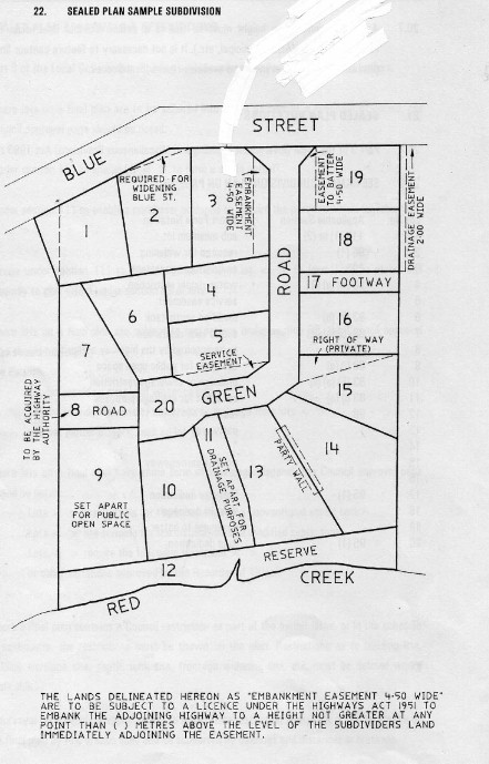
Right of Drainage means the right for a person authorised to do so to construct, maintain and repair sewers and drains over specified parts of another persons land for the removal of stormwater and other surplus water, but without doing unnecessary damage to the other persons land.

In the example on the right, see the Drainage Easement along the rear boundary of lots 18 & 19. Note that the easement does not 'Burden' lots 18 & 19.

SIMPLY:

This means that you cannot restrict the right of someone to construct and maintain pipes over that portion of a title that is defined as 'Drainage Easement', nor can you build a structure over such area.

HOW WE ASSIST :

We can determine the location of such a Drainage Easement on the ground and on plan to allow the design and construction of structures that do not intrude on this right.

Contact us for advice in relation to these matters. 

DTM (Digital Terrain Model)

glossary image: 

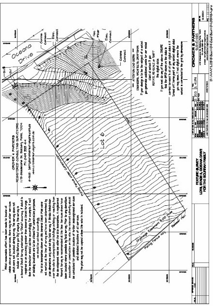
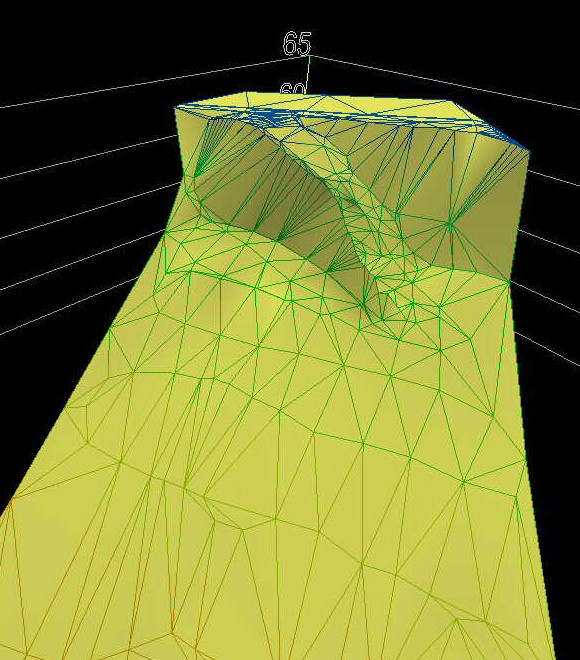
DTM.............................................Digital Terrain Model: is a digital representation of the terrain or a structure (gathered by scanning) that can then be utilised within CAD software to undertake design for further construction works. Most developments are based on a field DTM.

A DTM is the digital result of a field survey, making it possible for other associated consultants to process the field information. When viewing the examples to the right, the top image is the 'paper' result of the field work, whilst the bottom image is an image of the digital information that is provided to other consultants. Note the digital depiction of the driveway running down the embankment.

In simple terms, contours are created by 'solving' the triangles that are shown on the lower example; the sides of the triangle have a specific 'level' at their 'end' points which are then interpolated to create a contour at a 'contour interval' along the sides of the triangle.