Parking Easement
Parking Easement: means a right for a person authorised to do so to park a vehicle over specified parts of another persons land.
Tasmanian Surveying Consultants
Make direct contact with the principal:
0419 353 414, terry@tscsur.com.au or
Elliott on 0428 224 353, info@cromersurveyors.com.au
Parking EasementParking Easement: means a right for a person authorised to do so to park a vehicle over specified parts of another persons land. |
Part V AgreementPart V Agreement: More correctly Part V of the Land Use Planning and Approvals Act 1993. Covenants on a title can only be negative in nature; that is “not to remove trees from…..” since 1993 it has been possible to enter into agreements with council and other parties that are both positive and negative in nature. These may require the land owner to act in a certain manner when it comes to house colours, bush land maintenance and the like. A failure of the system is that Part V Agreements are not available for viewing at the Lands Titles Office but at the local Council. They are, however, referred to on the front sheet of a title document that they apply to. If under a Permit a Part V Agreement is required to be entered into, then the permit does not take effect until the day the agreement is executed. LUPAA defines ‘agreement’ as an agreement entered into under Part 5 of LUPAA.
The effect of these provisions is that a permit does not take effect until after any required Part 5 Agreements have been entered into. Any use or development undertaken in reliance on the permit prior to the Part 5 Agreement being executed may be in breach of the planning scheme.
SIMPLY: a registered agreement binding the property owner to behave in a certain manner. HOW WE ASSIST: we can search such Part V Agreements and advise you of their effect on your enjoyment of your title |
Party Wallglossary image: 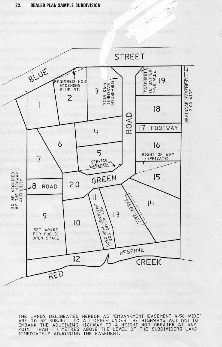 Party Wall: means a wall that straddles a boundary between two properties where express rights of support have been granted and reserved between the two affected property owners. On the example on the right there exists a Party Wall between lots 13 & 14. SIMPLY: HOW WE ASSIST: |
Passed InPassed In: If a property is not sold at auction because the owner's reserve price has not been reached, it is said to be "passed in". The highest bidder usually then has first option to purchase at the owner's reserve price. It is then possible to negotiate for the purchase, either on the same day or afterwards. Properties passed in are often sold shortly afterwards at a price close to the passed-in-figure. |
PermitPermit: means an approval or consent required by a planning scheme and granted by a local council in respect to the use or development of land. Note also that with a Subdivision Permit you have 14 days to lodge an appeal against a condition of the permit: "Your attention is directed to your rights of appeal under Sections 61 & 62 of the Land Use Planning and Approvals Act 1993 (as amended), that relates to appeals. These provisions should be consulted directly, but the following provides a guide as to their contents. An applicant can apply for an extension of time under Section 53(5C) of the Land Use Planning and Approvals Act 1993 as follows: (5C) An application may be made under subsection (5A) <https://www.legislation.tas.gov.au/view/html/inforce/current/act-1993-07...@Gs5A@EN> or (5B) <https://www.legislation.tas.gov.au/view/html/inforce/current/act-1993-07...@Gs5B@EN> , for an extension of a period during which a use or development in respect of which a permit was granted must be substantially commenced, at any time before the end of the period of 6 months from the day on which the permit has lapsed and, if the extension is granted, the permit is to be taken to not have lapsed on that day. In plan English terms this means that you can apply to extend the permit after the permit has expired but that application MUST be made within 6 months after the permit has expired. If your client say has a permit that expired on 9 August 2024, they can still apply for it to be extended but MUST lodge the application for an extension to Council prior to 6 February 2025. Please note that Council are not obliged to agree with an extension request. HOW WE ASSIST: We can advise on the appeal system and lodge the appeal on your behalf. We can also provide access to any necessary expertise that may be required to assist your appeal. |
Petition to AmendPetition to Amend is the term loosely given to the process of amending a sealed plan. SIMPLY: A sealed plan can only be amended by the local Council that sealed it. A person who wishes to amend a sealed plan (including the amendment or deletion of boundaries, easements, covenants, notations or any other detail on the plan) must make a Petition to Council setting out the terms of the amendment being sought. Because a sealed plan is a primary conveyancing document Council must serve notice upon, and hear any subsequent objections from, any other persons who would be affected by the proposed amendment. A third party can be such a person provided they are nominated by the Registered Owner (ie endorsed by the owner), or are the nominated Solicitor or Surveyor. Once Council is satisfied all affected persons have been heard, it may cause the amendment to be made with or without further modification. Council then notifies the Recorder of Titles of the amendment and the sealed plan and any other relevant title documentation is amended by the Recorder accordingly. Effectively this means that if you wish to amend a subdivision plan created under Council Approval, it is necessary to obtain the consent of all affected parties; usually ALL the owners of the lots on the plan + their mortgagees. Sometimes Council is the only affected party, such as with an amendment to an Easement to Batter. If a request to amend an earlier Sealed Plan is lodged with the Recorder then any subsequent affected Sealed Plans would also be amended as a part of the process. The process usually follows the following path (but not always!!) An easement removal requires an amendment to Plan XXXX which will require-
The DO search may be time consuming depending on how many dominant tenement parties are involved My costs are applicable + gst + Council fees & LTO fees. Lets put it forward in another way: A sealed plan is a primary conveyancing document and may only be amended by the Council for the municipal area in which the land is situated. An application also requires the consent of all persons with an estate or interest affected by the proposed amendment.
“A person with an estate or interest” may include registered proprietors of other lots on the plan, or registered proprietors affected by easements, covenants or other provisions in the schedule of easements.
A person who wishes to add, amend or delete any detail shown in a sealed plan or a schedule of easements must make application by petition to Council setting out the details of the amendment being sought. The petition must also accompanied by a separate Request to Amend document on a Blank Instrument Form.
Before lodging the amendment documents with Council an applicant must either serve posted notice on all persons with an interest in the Register, or obtain those persons written consents to include in the application.
Council must consider any objection from an interested person affected by the proposed amendment.
Council may then decide to either cause the amendment to be made (with or without modification) or refuse the amendment being sought.
The Council sealed Request to Amend document is then lodged by the applicant with the Recorder of Titles for registration.
The sealed plan amendment only takes effect upon the registration of a notice on the sealed plan, and any affected folios, by the Recorder of Titles. HOW WE ASSIST: We can advise you on the issues that may arise when dealing with a Petition to Amend relating to your particular title. |
PlanPlan: the result of a Survey; includes Surveyors Field Notes prepared in accordance with the Land Surveyors By-Laws and accepted Survey Methodology. All Surveys result in a Plan; Not all Plans are Sealed Plans (plans that require the approval of the local Council; Council place their "Seal" on the Plan, thus creating a "Sealed Plan"). A Plan may be prepared to support a Conversion Survey, a Torrens Title application, a Remark of boundaries or Identification Survey that results in important survey information being registered for future use. Some Stratum Surveys require a Plan to be produced (in addition to the Stratum Plan).
Plan of Survey ChecklistA checklist for those preparing Survey Plans: source Office of the Recorder of Titles Computations
Boundary Examination
|
PLANNING APPLICATION FORMS BY COUNCILPlanning Application Forms by SOUTHERN Council
CLARENCE CITY COUNCIL: Clarence City Council Planning & Subdivision https://www.ccc.tas.gov.au/wp-content/uploads/2018/10/Application-for-de... Provision of Further Information http://www.ccc.tas.gov.au/webdata/resources/files/Submission%20of%20Furt... Minor Amendment http://www.ccc.tas.gov.au/webdata/resources/files/Application_for_Minor_... Planning Scheme Amendment http://www.ccc.tas.gov.au/webdata/resources/files/plan-amend.pdf Applications Under Strata Act http://www.ccc.tas.gov.au/webdata/resources/files/Application%20under%20...
HOBART CITY COUNCIL: All Planning Matters http://www.hobartcity.com.au/Development/Planning
CENTRAL HIGHLANDS COUNCIL: Development Applications http://centralhighlands.tas.gov.au/wp-content/uploads/Application-Form-S...
GLENORCHY CITY COUNCIL: All Planning Matters http://www.gcc.tas.gov.au/content/upload/Planning_Permit_Application_For...
SORELL COUNCIL: All Planning Matters http://www.sorell.tas.gov.au/publications/forms/#1447212103061-19bd0a9c-...
BRIGHTON COUNCIL: Development Application http://www.brighton.tas.gov.au/images/stories/PDFs/Planning/Appliation_f...
TASMAN COUNCIL: Application for Planning Permit http://www.tasman.tas.gov.au/index.php?option=com_content&view=article&i... Application for a Sec 56 Amendment See pdf below
HUON VALLEY COUNCIL: Planning Forms http://www.huonvalley.tas.gov.au/application-forms-information-for-appli...
DERWENT VALLEY COUNCIL: Planning Permit https://www.derwentvalley.tas.gov.au/webdata/resources/files/Planning%20...
GLAMORGAN SPRING BAY COUNCIL: Development Application http://gsbc.tas.gov.au/wp-content/uploads/2016/06/Development-Applicatio...
KINGBOROUGH COUNCIL: Development Application /www.kingborough.tas.gov.au/wp-content/uploads/2017/05/Application_Form_f...
|
Planning Processes Relating to DevelopmentsPlanning Processes Relating to Developments: The flow chart below gives a general idea of the planning processes this office and your Planning Consultant would step through when preparing an argument for Development Approval. It is a growing document that would be updated from time to time. Stage 1
Stage 2
Stage 3
Stage 4
Stage 5
|
Planning SchemePlanning Scheme: means an instrument (document) prepared for a local council and subsequently approved by the Land Use Planning and Review Tribunal that makes provisions (sets rules) that relate to the use, development, protection or conservation of any land in the area covered by the Planning Scheme. |
Possession DatePossession Date: The date the purchaser physically takes possession of the property. Most often, it is the same as settlement date. |
Possession TitleSee the attached document published by the Recorder of Titles November 2019 |
Power of AttorneyPower of Attorney is a legal arrangement where a person (the donor) appoints one or more people (the donee/s) to conduct and manage the donor’s affairs. The power may be given for a specific task, or a defined period in time, or it may be for all purposes and for all time. The document must be registered with the Recorder of Titles before conveyancing documents can be executed by a donee on behalf of a donor. a donor may end the arrangement by revoking the appointment. SIMPLY: You may appoint someone to ‘sign’ on your behalf and revoke this appointment when you so desire. HOW WE ASSIST: We can direct you to the right professional to advise you and assist in preparing such a ‘power’. |
Pre Field Calcsglossary image: 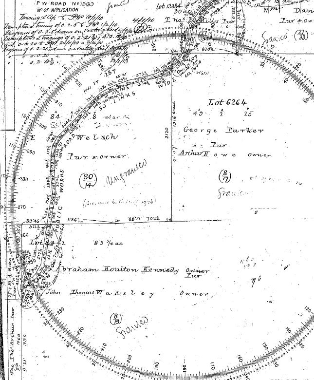 Pre Field Calcs: These are calculations that the surveyor must perform prior to entering the field to undertake a survey. They involve interpretation of Search and other data, some quiet often very old. See the example on this page of a very old search which defines some Road boundaries at a rural site. This must be interpreted and then compiled into a usable format on computer and intergrated with other adjoining search by the 'stiching' together of the data from the oldest information through to the most current available. The data is then loaded into a Data Recorder for use with survey equipment. This gives the surveyor direction for a starting point for his field survey and indeed usually forms the basis of his Final Survey. These calculations must be undertaken to allow the surveyor to exhaust all avenues of evidence prior to completion of his survey. Whether the resultant survey is an SIO Plan or a Sealed Plan, once his survey is 'registered' at the Lands Titles Office (LTO) it enters the Search Registry and becomes part of the information gained by other surveyors off into the future. Out of interest the attached plan is Search from the Central Plan Office (access via the Lands Titles Office, the LTO) and generates an additional Search Fee charged by the LTO. If part of a Survey instruction time on Pre-Field Calcs can be expensive often running to $500 and more. |
PricePrice (Purchase Price): In the case of real estate, the money consideration which is expected or given in exchange for a property. |
PrincipalPrincipal: See Agent. |
PRIORITY FINAL PLAN SCHEMEPRIORITY FINAL PLAN SCHEME Department of Primary Industries, Parks, Water and Environment LAND TITLES OFFICE Enquiries: OFFICE CIRCULAR No. 6/2020 On Monday, 30 November 2020 the Priority Final Plan (PFP) scheme will come into effect replacing the What has changed? From 30 November 2020 documents that are compliant with the PFP scheme, and do not require Fees for documents lodged under PFP will remain the same as the fees that were payable under the Early How to comply with the Priority Final Plan scheme If the correct fees, or any of the documents set out above are not provided, or, the original documents are All endeavours will be made to ensure that these lodgments are examined with utmost importance. The LTO will continue to develop and provide further information as the Priority Final Plan scheme and If you have any questions in the interim please email planslto@dpipwe.tas.gov.au or call Carolyn ROBERT MANNING |
Priority NoticePriority Notice: means a notice lodged with the Recorder of Titles by a person authorised to do so that reserves that person priority of document registration on a title for up to 60 days SIMPLY: When a surveyor or solicitor or like profession 'searches' a title to give advice, they take responsibility for that advice that is based on the title search as of that date. A Priority Notice advises that a matter relating to that title has been lodged, awaiting registration and that that matter has priority over any other dealing for 60 days. For example, when one purchases a house, their solicitor will lodge a Priority Notice on the title of the house under purchase so that the vendor cannot sell to others, create an easement or raise finance or similar; the Priority Notice gives preference to the sale first (for 60 days). HOW WE ASSIST: We carry out title searches on behalf of clients and in fact can provide them over the net. Engage Us to purchase your title. We can advise of any lodged Priority Notices. |
Private RoadPrivate Road: Is in fact a Private Drive! Means a way that is not subject to use by the public as of right. SIMPLY: Means a private driveway (that may look like a road) that is for private use only. Note that in general the word 'Road' means Public Road, whereas the general public often use the word 'road' to mean a driveway or way, when such is often 'Private Road' . HOW WE ASSIST: We can advise on the status of a road or driveway to ensure compliance with the above. We can determine the boundaries of such a road or drive. |
Private Treaty SalePrivate Treaty Sale: A sale negotiated between a seller (vendor) and a buyer, usually, but not necessarily, through in estate agent, and distinct from a sale by auction. |
ProclamationA Proclamation could be recorded on a land owner's title prior to 1993 and was a public notice that an authority, usually the crown, intended to acquire part or all of the land for a public purpose. A proclamation notice may remain on a title even though the various land resumption and acquisition acts that initiated them were repealed in 1993. The Land Acquisition Act 1993 uses notices rather than proclamations when land is to be acquired. |
Production SlipProduction Slip: Is the ‘receipt’ given to the lodging party (Surveyor, Solicitor etc) when a title is lodged at the Lands Titles Office to support a dealing, such as a subdivision. The Lands Titles Office will not accept documents from the surveyor for new title creation unless a Production Slip is attached. Quite often is a source of delay as the acting solicitor (or client) requests the holder of the title (normally a bank) to lodge the title; such request usually takes 3 weeks to enact and therefore results in a 4 week delay to proceedings. Some banks may have an arrangement with the Lands Titles Office where that office hold the titles on the banks behalf. The requesting party still need to gain a release from the bank for dealings to happen on the title. Different Banks deal with the release of titles in different ways. The CBA are the most difficult and will not release a title for lodgement at the LTO unless the Final Plans have been Signed & Sealed by Council and the CBA is furnished with a copy of the sealed plans. (a bit of a catch 22 as the LTO say they will not accept lodgement unless they receive the documents at the same time as Council!!) There is one opportunity to semi by-pass this situation. When lodging the Final Plan the origional is lodged with Council. A COPY is required to be lodged with the Lands Titles Office (LTO) at the same time. (At this time, the Production Slip is not available as the plan has not been signed and sealed). After the Plan has been signed and sealed, access is then available to the Production Slip and this and the Final Sealed Signed Plan can then be delivered to the LTO. SIMPLY: is a receipt when the title is lodged at the titles office. HOW WE ASSIST: we prompt the solicitor ‘early’ in the proceedings to lodge the title asap. |
Professional DutyProfessional Duty: The duty of care owed by a professional person to his or her clients. |
Professional NegligenceProfessional Negligence: The failure of a professional person to properly exercise a duty of care, usually leading to a loss suffered by a client or customer of the professional person, or them being placed in a worse situation than if the professional person had acted correctly. |
Property ManagementProperty Management: The business usually conducted by an estate agent composed of leasing of property, collection of rents, selection of tenants and generally the overall maintaining and managing of real estate properties for clients. |
Proposal Planglossary image: 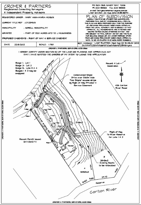 Proposal Plan: is a plan prepared to support an application to council to subdivide or develop a parcel of land. Is prepared from a combination of existing documents and field survey if necessary. The surveyor will always attempt to keep the cost of this section of your instruction to a minimum but he is also responsible to ensure that sufficient information is provided to council to allow an informed decision to be made. This is the reason why some Proposal Plans cost significantly more than others. It is always best to undertake at a minimum a field check of the compiled data, and quite often cost effective to undertake a Detail Survey. This information then forms the basis of any engineering design required to satisfy Permit Conditions. Be aware that Proposal Plans are sometimes used to support a contract of sale. These plans are not the result of a title survey and therefore differences are often encountered between the Proposal Plan and the final Title Plan, resulting in confusion for the purchaser. Proposal Plans carry the disclaimer: SHOULD THIS PLAN BE UTILISED FOR CONTRACTUAL PURPOSES FINAL SURVEY DIMENSIONS SHALL PREVAIL. THIS PLAN HAS BEEN PREPARED ONLY FOR THE PURPOSE OF OBTAINING PRELIMINARY SUBDIVISION APPROVAL FROM THE LOCAL AUTHORITY AND IS SUBJECT TO THAT APPROVAL. ALL MEASUREMENTS ARE IN METRES AND SQUARE METRES UNLESS OTHERWISE STATED AND ARE SUBJECT TO FINAL SURVEY. DO NOT USE THIS PLAN FOR BUILDING DESIGN OR ANY OTHER PURPOSE APART FROM OBTAINING PRELIMINARY SUBDIVISION APPROVAL. NOTE: TO BE DEVELOPED IN STAGES WHERE POSSIBLE. SIMPLY: is a plan prepared to give council the general concept of the proposed development. Is not a final survey and quite often reflects boundaries in a general manner only. HOW WE ASSIST: we prepare Proposal Plans on you behalf. |
Public Health ApprovalPublic Health Approval:is a term referred to in some old Planning Schemes and related to the obtaining of approval for an effluent disposal system. Usually related to those Council's that did not have the 'power' to handle such approvals themselves; ie they did not have deligated power from the Public Health office. Nowadays can be read as Council Health approval. SIMPLY: An old term that can now be read as Council Health Approval. HOW WE ASSIST: We can organise the necessary consultant to handle the obtaining of approval for any effluent disposal system. Contact us for advice in relation to these matters. |
Public Open Spaceglossary image:  Public Open Space: (on a Sealed Plan) means land set aside, usually as part of a planning permit, for public recreation or public gardens or for similar purposes of public pursuit. It is unfortunate that there are two meanings to the term Public Open Space. The term on the one hand relates to Land dedicated for the Public Use on a Sealed Plan. On the other hand it describes a land use (how the land is to be used) within a Planning Scheme. So, land shown as Public Open Space on a Planning Scheme does not mean that the public has rights of use over that land; it means that the registered owner must only use that land in accordance with the permitted uses defined within the Planning Scheme. With reference to the plan to the right Lot 9 has been Set Aside for Public Open Space. Note if these words are on a Title Plan then the land is set aside for Public use, even if the title to such land is still in the subdividors name. Further, unfortunatley some old Planning Schemes use the term 'Public Open Space' as a Zone description; when used in this context the words refer to the Land Use that applies to the land (ie. how the owner is allowed to use the land and for what purpose); it DOES NOT signify that the Public have a right to use the land. SIMPLY: Subject to the comments below, when large scale developments are undertaken Council's have certain rights in relation to 5% of the land being set aside for Public Open Space purposes. They also have the right to request that instead of land being given 5% of the value of the land is to be paid to Council. This is often the case with small subdivisions where 5% of a small lot is of little use to Council.This usually forms part of the Permit. It is State Government Legislation and not as commonly thought a Council whim. Council's do have the discretion to apply it or not; most do. On small developments it can be one of the bigger costs. The following rules apply when making a Subdivsion Submission to Council: NO OPEN SPACE SHOWN ON PROPOSAL CASH IN LIEU WANTED: Where no open space is shown on a proposal, council as a condition, can require cash in lieu if it is of the view that the subdivision gives rise to the need for the provision of open space NO OPEN SPACE SHOWN ON PROPOSAL LAND WANTED: Where council have formed the view that the proposal will give rise to the need for public open space that is not provided in the proposed subdivision and they are of the opinion that LAND should be provided, their only option is to REFUSE the subdivision on the grounds that the proposal should be altered to include public open space OPEN SPACE SHOWN ON PROPOSAL CASH IN LIEU WANTED: Where council have formed the view that the public open space provided in the proposed subdivision does not suit the public convenience or there is no other means of providing public open space which would be of public benefit, their only option is to REFUSE the subdivision on the grounds that the proposal should be altered to omit public open space OPEN SPACE SHOWN DIFFERENT LOCATION WANTED: Council may, in lieu of the public open space set out on the proposal plan, ask that the final plan contain 'the area set out in the plan annexed' as public open space and further advise that the subdivider is to sell that area to the Council for the sum of $1.00 and further the subdivider is to execute a transfer of the land in favour of the Council immediately upon the issue of titles OPEN SPACE SHOWN ON PROPOSAL EXTRA LAND WANTED: Council have the power to ask for extra public open space but must pay for that in excess of 5% OPEN SPACE LESS THAN 5% SHOWN ON PROPOSAL Council have the power to ask for the difference between the area shown on the plan as public open space (if it is less than 5%) and 5%, to be paid as cash in lieu COUNCIL CAN'T DELETE POS AND ASK FOR CASH IN LIEU It is not possible for a council to impose a condition on a permit approving a plan of subdivision which deletes public open space provided in the plan and then to require a contribution of cash in lieu of public open space by a further condition COUNCIL TO ESTABLISH A NEED It is not enough that council has a policy requiring contribution, it must make an individual assessment of each subdivision, it must form the view that the subdivision will give rise to a need ADHESIONS PUBLIC OPEN SPACE SHOULD NOT BE ASKED FOR: In general terms, unless a new lot is being created, it is hard to see how a Council could bona fide come to the conclusion that the plan of subdivision created an additional need for public recreation space such that such space should be included(or cash in lieu). GENERAL COMMENTS POS: HOW VALUED: VALUE IS BASED ON THE VALUE OF THE NEW LOTS CREATED LESS DEVELOPMENT COSTS STANDARD POS CLAUSES USED BY COUNCILS. 1. The land shown on the proposal plan as “public open space” is to be sold to the Council by the subdivider for the sum of $1.00 and the subdivider will execute a transfer of that land in favour of the Council immediately upon the issue of titles. 2. That in lieu of the public open space set out on the proposal plan the final plan is to contain the area set out in the plan annexed as public open space and is to sell that area to the Council for the sum of $1.00 and further the subdivider is to execute a transfer of the land in favour of the Council immediately upon the issue of titles. 3. The subdivider shall sell to the Council the land shown on the plan as public open space for the sum of $1.00 and the subdivider shall execute a transfer of the land in favour of the Council immediately upon the issue of titles. 4. The subdivider shall also pay to Council within 90 days of demand an amount of money which bears the same ratio to the value of the whole area comprised in the plan as one twentieth of that area less the area already provided for public open space in the proposal plan and any area created by the final plan of the littoral or riparian reserve bears to the whole area. 5. The subdivider prior to the lodgement of the final plan is to provide security for the above payment by a bond and bank guarantee as set out in Section 117(4) of the Local Government (Building and Miscellaneous Provisions) Act 1993. 6. The subdivider is to pay to the Council an amount which bears the same ratio to the value of the whole of the area comprised in the plan as one twentieth of that area less the area provided for public open space in the proposal plan and any area created by the final plan of the littoral or riparian reserve bears to that whole area. 7. Prior to the lodgement of a final plan the subdivider is to provide security for the payment referred to above by bond and guarantee as set out in Section 117(4) of the Local Government (Building and Miscellaneous Provisions) Act 1993 If Public Open Space already taken with a previous subdivision, it should not be taken again. |
Public RoadPublic Road: means a way maintained by a highway authority and subject to use by the public as of right. SIMPLY: This means that if a Council or Department of Roads maintains a road then that road is public road. Note that the word 'road' alone is considered to mean Public Road, whereas the general public often use the word 'road' to mean a driveway or way, when such is often 'Private Road' HOW WE ASSIST: This issue quite often arises when an owner wishes to develop or further subdivise their title onto a road that is of dubious construction and status. Quite simply, if the road is maintained by Council it is a Public Road and provides a legal frontage to satisfy the Recorder of Titles. |
PurchaserPurchaser: In real estate transactions, the person who is buying the property. |