Sketch by way of illustration only: means that whilst the estates (ownership) in the title are guaranteed as correct; the boundaries are not derived from a registered survey. The boundary measurements on a sketch plan need to be interpreted in conjunction with any occupation (fences) or other boundary evidence that exists on the ground.
In other words, means a description of land converted from a general law deed or conveyance where there was no survey data and where the deed was based on a verbal description only. Such titles do not support Strata Development and therefore need to be converted to Real Property Act title (or Torrens Title) by a surveyor undertaking a title survey and preparing a Plan of Survey.
Architects, Designers, Builders BEWARE:
Sketch By Way of Illustration: The Title Plan LOOKS like other Titles but it is based on non survey data and usually no field measurements. You CANNOT design structures using such titles. (indeed even Torrens Titles should be field checked prior to design). I have known cases of multi million dollar buildings being designed and construction commenced on such plans only to find that the measurements simply did not reflect the land available; and this by a large reputable Architectual firm.
NO Design and Construction without a new field survey by a Registered Surveyor to determine boundarys. NO blind acceptance of boundaries derived from the digital data off the 'List'. Again such data LOOKS like the real thing but read the Disclaimer placed by the Government.
Tasmanian, in layman’s terms, 3 types of titles
·
Torrens Title – The plan attached to these titles is based on field survey by registered surveyor
·
Sketch by way of Illustration - Is not based on a field survey.
·
Conveyance or deed – reasonably rare and usually a verbal description with no plan
Let’s Talk about Sketch By Way Of Illustration
The title for your site is based on a General Law Deed and the plan accompanying that title is a Sketch By Way Of Illustration Only Plan
This means that whilst the ownership shown on the title is guaranteed as correct, the boundaries may not be derived from a field survey
Therefore, the boundary measurements on such a sketch plan need to be interpreted in conjunction with any occupation (fences) or other boundary evidence that exists on the ground, meaning distances on the plan may not represent the distance on the ground. In the States of Australia Registered Land Surveyors are the only persons entrusted and Certified to deal with and make decisions relating to Boundary Definition.
In this situation it is recommended that no design or construction take place without the benefit of a field boundary survey to accurately determine boundary locations.
Undertaking a boundary survey such as above negates concerns for all parties regarding the reliability of the dimension shown on the Sketch Title Plan and all gain the benefit of correct boundaries before proceeding into the design stage. Any deficiencies in title are highlighted sooner rather than later.
If a strata development is Proposed the Title needs conversion from a Sketch to a full surveyed title (ie a Torrens Title)
Strata is not possible on a Sketch By Way of Illustration title.
The conversion process includes lodging the resultant plan at the Lands Titles Office (LTO) for their examination and registration of the new title. Titles Office Fees are applicable to such registration, usually close to $1000. No Council approval is necessary.
You need to advise this office if a strata development is proposed on your site.
Many Detail and Contour Surveys are carried out by Engineering Surveyors and the like. Registered Surveyors are the only professionals licensed to deal with boundary matters in Tasmania.
If you have a Sketch By Way Of Illustration Title Plan you need a Registered Land Surveyor to determine boundary matters for you.
SIMPLY:
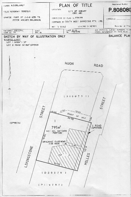
See the example adjoining. The plan 'looks' like every other title but the measurements and areas (if any) are a draftspersons interpretation (possibly of a conveyance) only. For many years there were two forms of title within Tasmania; General Law Deed (or conveyance) and Real Property Act title (or Torrens Title). Two main differences existed between the two; with General Law, there was a NEW deed or conveyance drawn up for each dealing and the land was described in a verbal manner (eg. easterly along Collins land to the creek etc). With Real Property Act title, there is one title, with each new dealing being registered on that document, together with a surveyed (and therefore survey plan) description of the land.
In recent times there has been a move to 'convert' general law land to Real Property Act title; This is mostly complete apart from the fact that the conversion only went as far as to create one document with the listed dealings; the description of the land remained as before, verbal as per a conveyance. To assist interpretation of this description, a sketch plan was created (a 'Sketch By Way of Illustration Only') by the Titles Office and attached to the title. The description of the land is therefore not supported by survey.
Buyer beware!!!, an Identification Survey (check survey) should (must?) be undertaken prior to finalising a purchase of such a title (indeed any title). Similarily a Remark Survey should be undertaken if any form of construction is to take place.
Another document describes these titles as follows:
Over the past 30 years the Tasmanian government has progressively been converting general law deeds (or conveyances) to Torrens title as they are presented to the recorder of titles for registration (upon sale, mortgage, etc.)
The converted titles are made up of two parts; the schedules of ownership interests in the land and the plan of title.
Many old deed boundaries (or conveyance boundaries) were verbally described rather than being derived from a survey and consequently current legislation provides that the conversion plan prepared by the recorder of titles from a verbal description be a "sketch by way of illustration only".
Generally speaking this means that boundaries that follow lines of old & contented occupation may be a better representation of ownership than conversion plan measurements, subject to Boundary Redefinition Methodology.
There are "rules" in the boundary re-instatement process based on common, case & statute law; therefore the boundaries in a sketch plan can only be updated or amended by a new plan of survey that needs to be lodged with, and approved by, the recorder of titles.
Some old deed boundaries (or conveyance boundaries) are derived from actual survey and the recorder of titles gives the conversion of these deed boundaries the same status as torrens title surveys.
HOW WE ASSIST:
We can view the title and advise you of the likely need for a Identification (check) survey prior to purchase, as the available dimensions and area of such a block may not be consistent with the title documents. We can convert the title to allow Strata Development.