Make direct contact with the principal:
0419 353 414 or Elliott  0428 224 353
info@cromersurveyors.com.au

Glossary

A | B | C | D | E | F | G | H | I | J | K | L | M | N | O | P | R | S | T | U | V | W | Y | Z

BAL (Building Attack Level) relating to Fire Risk

Fire BAL or Bushfire Attack Level: The Department of Justice web page found here

http://www.justice.tas.gov.au/building/regulation/building_in_hazardous/...

advises in part as follows:

There are special requirements for the design, construction or alteration of certain types of buildings that are situated in a bushfire-prone area.

Am I in a Bushfire-Prone Area?

Your land is most likely to be in a bushfire-prone area if you have, within a 100 metre radius of your building site:

  • any unmanaged vegetation (including grass) greater than 1 hectare in area; or
  • vegetation that is not on land that is zoned general residential, inner residential or village

The risks to a habitable building from that vegetation will need to be assessed before new building work is permitted.  

Mapping of bushfire-prone areas for planning schemes is being developed to assist owners and developers.

Note that other vegetated land within 100m of the building site, that is not zoned as residential, including private forest, farmland or a Crown land reserve, or is not one of these three types of residential zoned land, still has to be assessed for its potential effect on the subject building site.


Things have changed in recent times and accordingly we refer you to a number of good web sites below to better understand the requirements relating to these locations

Australian Standard®
Construction of buildings in bushfire-prone areas

https://law.resource.org/pub/au/ibr/as.3959.2009.html


http://www.fire.tas.gov.au/Show?pageId=colBuildingForBushfire

http://mybuildingcertifier.com.au/forms/MBC-BAL-19-Summary.pdf


Balance

glossary image: 

Balance (Title) See also "Compiled Plans": When only a portion of a title is the subject of a subdivision, the Lands Titles Office requires the surveyor to prepare a plan that reflects the land that is left behind; ie the ‘Balance’. This land portion is quite often NOT surveyed even though it will end up with a new title number and has all the appearances of being surveyed. It is quite often recognised as such on the plan when there is a notation on the plan that "Lot XX is compiled from Title XXXX and this survey". Quite often is a bone of contention as owners sometimes think that because they have a new plan and the surveyor has been on site, that their balance has been surveyed. Balance Plans are usually ‘compiled’ plans.

The example to the right shows what appears to be a survey of two lots; however, view the notation on the Sealed Plan (top left) where it indicates that Lot 2 has been compiled from CTXXXX and this survey". In other words, Lot 2 has NOT been surveyed. (a further clue is that there are no 'bearings' shown around the boundaries of lot 2, as there are for lot 1)

SIMPLY:

a visual depiction of the land remaining after a subdivision

HOW WE ASSIST:

we prepare these plans in accordance with the Titles Office requirements.  

Batter Easement or Easement to Batter

glossary image: 

Batter Easement means the right for a highway authority (usually the Local Planning Authority) to maintain the slope and stability of higher land adjoining a highway to ensure the adjoining land does not spill onto the highway.

Within a Batter Easement or Easement to Embank some Councils will allow building or the construction of walls etc but only after they are satisfied that the Road is still ‘supported’ . This usually requires the certification of an engineer followed by a Petition to Amend the sealed plan. See the plan example to the right, Easement to Batter passing through lot 19.

The Petition to Amend can be simple as the only interested parties are the Planning Authority and the land owner.

Contact us for advice in relation to these matters. 

Blackwater & Greywater

Blackwater & Greywater There are two types of wastewater created in a home, each of which can be treated and used in various ways – Blackwater and Greywater.

Blackwater is water that has been mixed with waste from the toilet. Blackwater requires biological or chemical treatment and disinfection before re-use. Blackwater should only be re-used outdoors.

Greywater is wastewater from non-toilet plumbing fixtures such as showers, basins and taps. Depending on its use, greywater can require less treatment than blackwater and generally contains fewer pathogens.

Treated greywater can be re-used indoors for toilet flushing and clothes washing, both of which are significant consumers of water. Greywater can also be used for garden watering. The average Australian home produces about 113 litres of greywater per day.

SIMPLY:

Blackwater is the 'nasty', not to be reused inside.

HOW WE ASSIST:

We are closely aligned with professionals dealing with the treatment of black and grey water.

Body Corporate

Body Corporate in relation to a strata scheme means the controlling body that is made up of all the lot owners in the scheme primarily to administer, manage and control the strata site.

There are Benefits to Developers of Strata title properties by engageing a Strata Title Manager. See the attached 'flyer' relating

ie. Body Corporate Under the latest type of legislation relating to Villas, Town Houses, Flats and Home Units, the control and administration of common property is vested in a statutory Body Corporate which comes into existence automatically on the registration of the strata scheme, and to which the provisions of the Companies Act do not apply. The registered proprietors of the units are the only members of the Body Corporate. 


A flow chart of how the Body Corporate comes into being follows:

  • The stratum plan is prepared in the final weeks of construction
  • The plan then goes to council for ‘final sealing’ after checking for compliance with the permit is determined
  • Once sealed, the plan goes to the Lands Titles Office with the Draft First By-Laws
  • Titles are issued and the Draft First By-Laws become the First By-Laws
  • At this finite point in time, the developers own all the units and therefore constitute the Body Corporate, acting under the First By-Laws
  • When transfers to the new owners are lodged (i.e. settlement occurs and as such the new owners take title) they then gain membership on the Body Corporate. After a period of 3 months has elapsed OR 50% of the units are settled, the developer must hold the first Body Corporate meeting
  • As such, at that first Body Corporate meeting that will be run by the the developers, the owners will all be Body Corporate members

Boma Method

glossary image: 

Boma Method: A method of measurement of lettable areas; now superceded by a product produced by the Property Council of Australia (http://www.propertyoz.com.au). There has been a reprint of the 1997 Method of Measurement, the 2008 version provides guidelines for measuring floor space in leased premises. The guidelines, covering office, industrial and retail premises, aim to provide consistency by documenting a defined approach to floor space measurement that is both practical and cost effective.

The extract adjoining is a section out of the 1997 BOMA manual showing the extent that one needs to go to to measure lettable areas under this method. The pink areas are considered 'lettable areas'.

Bona Fide

Bona Fide: In good faith, honestly' without fraud, collusion , or participation in wrongdoing. 

Bond & Garantee

Bond & Garantee: relates to a 'letter of credit' from a bank garanteeing to the local council that if you, the developer, do not complete Permit Conditions, then the bank will provide funds to complete same, using your money.

SIMPLY:

If the title survey and engineering design are completed and approved by council, a letter of credit can be left with council to cover outstanding constructions works. This allows titles to issue and settlements to take place thus assisting cash flow.

HOW WE ASSIST:

We can assist you and your Consulting Engineer to finalise all documentation to allow a bond to be prepared.  

Boundaries and the List

23-10-2019  A very interesting artical/email from the Office of the Surveyor General

Scott Strong   |   Program Manager Cadastral Standards  |   Delegate of Surveyor General

Location Services    |   Land Tasmania


About Cadastral Surveys includes two pages of detail. The first explains the origins of the cadastral system in Australia before highlighting the limitations in usage of digital “cadastral boundaries" shown on LISTmap, which is dealt with in detail on the Property Boundaries on LISTmap child page. 


Practitioners are encouraged to share this content with the broader public and feedback is invited.  As mentioned in the SSSI seminar at Utas in May 2019, LISTmap Identify Objects window will soon be updated with a visually significant warning on the usage of digital cadastral boundary information that will ultimately link to these pages.


New Useful Links on the Cadastral Standards Background Information page, copied below, will be of particular value to candidates or recently registered surveyors


​            Boundaries and the Common Law​

Paper by Glenn Campbell delivered at Graduate Surveyors Weekend Seminar 2013, 4-6 Oct 2013, University of Southern Queensland​ 

Draw conclusions on the wall : Defence of the Monumented Cadastre​


Article by Mick Strack (2017) in ​Australian Property Law Journal. 26. 1. ​

​            The Judicial Functions of Surveyors

Essay by Thomas Cooley (Chief Justice, Supreme Court of Michigan, 1864–1885)​ at Wiley Online ​


All practitioners – old and new – will find the new content on the Cadastral Standards Historical Information, highlighted in the red squares in the image below,  of interest.


Kind regards,


Scott Strong   |   Program Manager Cadastral Standards  |   Delegate of Surveyor General

Location Services    |   Land Tasmania


Department of Primary Industries, Parks, Water and Environment

134 Macquarie Street Hobart TAS 7000

GPO Box 44 Hobart TAS 7001

T: 03 616 54175   |   M: 0419 876 003   |   E: Scott.Strong@dpipwe.tas.gov.au

www.dpipwe.tas.gov.au   |   www.thelist.tas.gov.au   |   www.tasmap.tas.gov.au

Boundary Fences

Boundary Fences: Some matters relating to boundary fences.

1. DISPUTES BETWEEN NEIGHBOURS

Neighbours do not always see eye to eye. From time to time a problem will arise which needs to be resolved. These problems can be varied and putting up or repairing a fence between properties is a common one. These types of problems can be sorted out if the neighbours concerned are willing and know how to go about it.

2.THE BOUNDARY FENCE ACT AND YOU

The Boundary Fences Act 1908 tells us what the law is in Tasmania for erecting and repairing boundary fences. The Act will not apply to you if your property or the property concerned is unoccupied Crown land, a public reserve, land owned by the Forestry Commission, land in a subdivision which has not yet been sold separately, or if you are simply renting the property concerned. It is usually the owner of the property who is responsible for erecting or repairing a boundary fence, not the tenant.

3.ERECTING OR REPAIRING A BOUNDARY FENCE

If properties side by side are not divided by a sufficient or rabbit-proof fence or the fence needs repairing, the Act states the neighbours shall be legally bound to erect or repair the fence.

4. DEFINING A SUFFICIENT FENCE

In rural areas, a sufficient fence is a fence which can keep livestock in or out. Where the fence is in a city or town, or next to another home, then it means a fence which the neighbours have agreed on or is usual in the area. A boundary fence must be along the boundary line. Where the boundary is uncertain because it is a river, creek, lake, pond or is rocky land the neighbours can agree on the line the fence should take.

HOW TO MAKE YOUR NEIGHBOUR HELP OUT

If you want to put up or repair a boundary fence and want your neighbour to help out with the cost, you must serve a notice on them to erect a fence or repair a fence. To serve such a notice you can give it to your neighbour by handing it to him or her, or send it in the mail. If you put up a fence or repair one without serving either of these notices on your neighbours, they do not have to help out with the cost.

6. IF YOUR NEIGHBOUR DOES NOT AGREE

If your neighbours do not agree with your proposals for erecting or repairing a fence, they can object. To do this they must put their objection in writing and serve it on you within 21 days of having received your notice. If after 30 days you have not received an objection from your neighbour, you can go ahead and erect or repair the fence and recover half the cost from your neighbour. If an object has been made and you cannot resolve the dispute you should both meet with a mediator to resolve the issue.

7. GOING ONTO YOUR NEIGHBOUR'S PROPERTY

If there is no possible way to erect or repair the fence from your. own side of the boundary, then you can go onto your neighbour's land but only at reasonable times. If your neighbour's land is a crop, garden, orchard, plantation or shrubbery, then you must get their permission first. If you damage your neighbour's property while doing the work, either on purpose or if you did not take care, then you may be bound to pay compensation to your neighbour for the damage caused.

SIMPLY:

You and your neighbour have a legal obligation to share the cost of a common fence, usually 5ft or 1.5 metres in height, or though one can ask for it to be higher up to 6ft or 1.8metres, the extra being at their expense. Anything different or in excess of the above should be clarified with Council's Planning Scheme and may need a Planning Permit. Fences should be constructed on the boundary of the properties involved.

HOW WE ASSIST:
We can redefine the boundary line for you to ensure that the fence is constructed in the right spot. We can also check Planning Scheme issues for you to ensure any variances are in accordance with the Scheme.

BOUNDARY FENCES ACT 1908 NOTICE FORM

NOTICE TO JOIN IN ERECTING A SUFFICIENT OR RABBIT-PROOF FENCE

In pursuance of the Boundary Fences Act 1908 I hereby give you notice as the owner of the land next adjoining the land belonging to me situated at:
...........................................................
..................................
............................................................
..................................

that require you to join in erecting a sufficient fence (or rabbit proof fence) under the provision of that Act between our respective lands and I propose that the boundary to be fenced be as follows:
............................................................
.................................
............................................................
.................................

and that the kind of fence to be erected be as follows:
............................................................
..................................
............................................................
..................................

Your attention is directed to the following provisions of that Act, namely:

Section 10, which empowers you within twenty one (21) days after service of this notice to object to any proposal contained in this notice and provides for arbitration in case we do not come to an agreement, and Section 12, which empowers me to erect the fence and recover from one half of the actual cost together with interest if within thirty (30) dates after service of this notice we do not enter into an agreement and if no notice of objection has been served by you upon me.

Dated
at ..........................this.............day of................200..

....................
..................................
(signature of the person giving notice)

..................................
(witness' signature)

Boundary Redefinition

glossary image: 
Page 1 of a Redefinition Survey
Page 2 of a Redefinition Survey

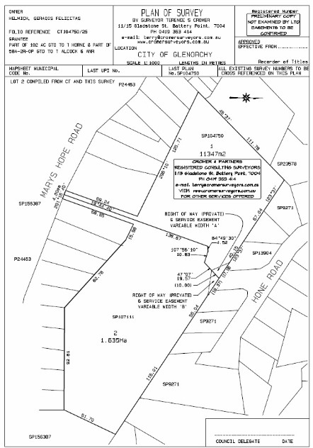
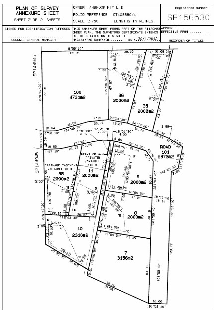
Boundary Redefinition: The surveyor is responsible by State Legislation to ensure the integrity of the State Cadastre. He\she has delegated authority to undertake boundary definition within the State to a specified standard. The survey must be undertaken in accordance with accepted Survey Methodology and results in a Plan being produced.

Sometimes, within the course of a field survey, it becomes apparent that there is a problem or a particular aspect of his\her survey that requires further investigation and clarification.

This may only be apparent once the surveyor enters the field to undertake his\her survey. Consequently, in some cases, estimates are exceeded in the course of the surveyor carrying out his\her resposibilities as described in the relevant Acts.

We will always attempt to contact the client from the field to explain this situation if it arises and the reason for the increase in estimated fees. In some cases such increases can be quite onerous.

Matters that effect the Boundary Redefinition process are (but not restricted to):

1. The age and proximity of the most recent adjoining surveys and the survey marks that may or may not still exist. The older the most recent survey, the less likelihood that survey marks from that survey still exist. Unfortunately, the existence of such marks cannot be confirmed until the survey is under way.

In many cases there are NO marks left in the vicinity. This then requires the surveyor to survey to out lying corners to either find additional old marks OR to utilise other further afield evidence to satisfy himself the land that his client is entitled to.

2. The slope of the land.

3. The extent and thickness of the vegetation. Note that surveys by GPS require reasonably clear access to the sky.

4. The proximity or otherwise of Map Grid of Australia (MGA) survey control marks. (we are now required by law to connect to such MGA control). These are red coloured ‘brass plaques’ placed at random throughout the state.

5. All surveys that involve the placement of survey marks MUST be registered at the Lands Titles Office by means of the preparation of a Plan and lodging of same.

6. See notes below concerning Boundary Redefinition for reasons why estimates are sometimes exceeded & Survey Methodology for an explanation of why we do what we do!

Survey Methodology: Historically, surveyors entered the field with pack horses, a cook, camp equipment, someone to look after the horses, 5 chainmen, some axemen and most likely a survey assistant or two. Field work represented 95% of the time involved and therefore the equivalent percentage in the final fee.

We have been gradually working towards a situation where now with such ‘tools’ as GPS (note not always the total solution) we spend 50% of the time in the field and the remainder in front of the computer. Boundary Surveys & solutions by GPS require very good preparation and uploading of resultant data to the GPS Data Recorder.

GPS is simply another, quicker way of measuring. It does not supply a magical solution to boundary issues but allows the surveyor to more quickly seek solutions in the field, if he\she is well prepared. His\her expertise is still required to form an opinion of the boundary entitlements in accordance with accepted practice (best available evidence).

Some regulations that come into play when boundaries are under survey are:

(A) The surveyor must form an opinion of the location of the end of a boundary line if attempting to place a mark along the boundary line (ie a line peg).

(B) The surveyor must connect into to adjoining boundaries by their surveys or the best available evidence to ensure that adjoining properties maintain their entitlements.

(C) Best available evidence may mean, due to lack of information or evidence, that the surveyor must measure further afield to come to a ‘best’ opinion. Note that ‘further afield’ can mean either further ‘away’ in distance or further back in time and age of surveys to come to a considered opinion.

(D) Measurements are not necessarily what boundary definitions are about. A quote from A G Foxhall’s Handbook for Practising Land and Engineering Surveyors:

“In the absence of evidence to the contrary the following is the order in which different methods of definition should be adopted, subject to abnormal conditions:

(1) Natural features, such as rivers, cliffs etc.

(2) Original marking of grant boundaries, road surveys, alignment or resumption surveys.

(3) Monuments and abutments.

(4) Original marking of private surveys.

(5) Occupations.

(6) (Lastly, and least satisfactory and only to be adopted when the previous methods do not apply) measurement.

This order is not arbitrary,……”

Measurement is a ‘tool’ used by the surveyor to assist in forming his\her opinion of a boundary. Once he\she has formed an opinion the surveyor then must mark and reference his\her survey and provide appropriate measurements on a plan lodged with the Recorder of Titles. The need to undertake new survey measurements to a certain accuracy (as set down by legislation) and prepare a plan is to ensure that in future, the then surveyor can rely on those measurements and plan to assist in redefining the relevant boundaries.

Please Contact us if you have any queries in relation to this matter

Boundary Redefinition Methodology

Boundary Redefinition Methodology: The surveyor is responsible by State Legislation to ensure the integrity of the State Cadastre. He\she has delegated authority to undertake boundary definition within the State to a specified standard. Sometimes, within the course of a field survey, it becomes apparent that there is a problem or a particular aspect of his\her survey that requires further investigation and clarification. This may only be apparent once the surveyor enters the field to undertake his\her survey. Consequently, in some cases, estimates are exceeded in the course of the surveyor carrying out his\her resposibilities as described in the relevant Acts. We will always attempt to contact the client from the field to explain this situation if it arises and the reason for the increase in estimated fees. In some cases such increases can be quite onerous. Please Contact us if you have any queries in relation to this matter.

Survey Methodology: Historically, surveyors entered the field with pack horses, a cook, camp equipment, someone to look after the horses, 5 chainmen, some axemen and most likely a survey assistant or two. Field work represented 95% of the time involved and therefore the equivalent percentage in the final fee. We have been gradually working towards a situation where now with such ‘tools’ as GPS (note not always the total solution) we spend 50% of the time in the field and the remainder in front of a computer. Boundary Surveys & solutions by GPS require very good preparation and uploading of resultant data to the GPS Data Recorder. GPS is simply another, quicker way of measuring. It does not supply a magical solution to boundary issues but allows the surveyor to more quickly seek solutions in the field, if he\she is well prepared. His\her expertise is still required to form an opinion of the boundary entitlements in accordance with accepted practice (best available evidence). Some regulations that come into play when boundaries are under survey are:

(A) The surveyor must form an opinion of the location of the end of a boundary line if attempting to place a mark along the boundary line (ie a line peg).

(B) The surveyor must connect into to adjoining boundaries by their surveys or the best available evidence to ensure that adjoining properties maintain their entitlements.

(C) Best available evidence may mean, due to lack of information or evidence, that the surveyor must measure further afield to come to a ‘best’ opinion. Note that ‘further afield’ can mean either further ‘away’ in distance or further back in time and age of surveys to come to a considered opinion.

(D) Measurements are not necessarily what boundary definitions are about. A quote from A G Foxhall’s Handbook for Practising Land and Engineering Surveyors: “In the absence of evidence to the contrary the following is the order in which different methods of definition should be adopted, subject to abnormal conditions:

(1) Natural features, such as rivers, cliffs etc. Also see our section on Ad Medium Filum.

(2) Original marking of grant boundaries, road surveys, alignment or resumption surveys.

(3) Monuments and abutments.

(4) Original marking of private surveys.

(5) Occupations.

(6) (Lastly, and least satisfactory and only to be adopted when the previous methods do not apply) measurement. This order is not arbitrary,……” Measurement is a ‘tool’ used by the surveyor to assist in forming his\her opinion of a boundary. Once he\she has formed an opinion the surveyor then must mark and reference his\her survey and provide appropriate measurements on a plan lodged with the Recorder of Titles. The need to undertake new survey measurements to a certain accuracy (as set down by legislation) and prepare a plan is to ensure that in future, the then surveyor can rely on those measurements and plan to assist in redefining the relevant boundaries.

Bridging Finance

Bridging Finance: The need often arises for purchasers to complete settlement of a real estate transaction prior to the date that the finance or the proceeds of another sale becomes available. In these circumstances, it may be necessary to obtain bridging finance (a temporary loan) during the period of the time gap and to comply with the terms of the contract in regard to settlement pending the availability of the long term finance. 

Building Envelopes

glossary image: 

Building Envelopes: Sometimes council require that building on an allotment is restricted to a certain location on the lot. This may be due to effluent disposal matters, scenic controls, services or adjoining owner privacy issues. This restriction is usually shown on the survey plan as a series of dotted lines with lettering attached, and should be read in conjunction with the Schedule of Easements.

The plan to the right has a Building Envelope on most lots as shown by dotted lines and the letters A, B C...etc. These letters will be referred to in the Schedule of Easements.

SIMPLY:

a restriction on the building location on a lot

HOW WE ASSIST:

we can redefine the location of the envelope and assist you with your house setout.