Please Write a Review if you feel this page has been of assistance.
"Identification Survey" means a survey required for the purpose of locating and identifying a particular title boundary, including the relationship of improvements to that title of boundary, but not requiring the boundary to be marked.
Note: Should a Land Surveyor place a formal boundary mark at a title corner or along a title boundary that surveyor is required to lodge formal title boundary remak notes at the Land Titles Oiffce as a legal record of the survey. This protects the land owner should anyone question the location of future site fencing or improvements to the title.
Can only be undertaken by Authorised Registered Surveyors. We employ such surveyors to undertake this type of Survey.
An Identification Survey confirms or otherwise that what you have seen on site is reflected in the title you purchase. It clarifies the relationship between the improvements (fences, buildings, sheds, driveways etc) at the location with the title boundaries. It does NOT redefine the boundaries of the site (ie the boundaries are not certified as correct for legal purposes) nor provide level or contour information, it gives a general relationship between the boundaries and the improvements. It does NOT result in survey marks, boundary or corner pegs being placed and should NOT be used as the basis of a building or structure setout. If instructing firstly have a look at those links relating to Survey Fees, Terms of Contract and Survey Methology. Please note there is no Identification Survey that generates fees less than $1800 + gst. A Rural Ident can generate fees of $4000 + gst and higher depending on size and vegetation. All Identification surveys are subject to Survey Methodology and the rules of Boundary Re-establishment which can result in substantial increase in fees. Older surveys, travel, slope and vegetation effect survey costs. Occasionaly there is a need to lodge an Identification Survey as a SIO (Survey Information Only Plan) to register any survey matters that need to be available to the Register. This generates additional costs.
It should be noted that if your instruction relates to a Strata Title, then formal Identification of Common Property boundaries will not occur unless specifically instructed to do so. Likewise with any Easements that may be applicable. Easements are not shown on a Strata Title or Plan & a search back through the Register is required.
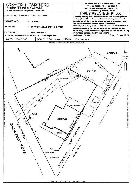
The example to the right is extreme but is a real life case. An Identification Certificate will carry the following or similar report:
We refer to your instructions in relation to the above and enclose our Identification Certificate as instructed. We ask you to peruse the enclosed and ensure that same is in accordance with your understanding of instructions given
The enclosed survey is an Identification Survey and as such is not registered at the Lands Titles Office for future boundary identification. We refer you to our web page at
(the glossary section) for a full description of such Identification Surveys. A glance at the “Subdivision Overview” section on the front page will also give you an idea of why we do what we do and our Terms of Contract.
We enclose our account covering our time and costs involved and again ask you to contact us with any queries you may have.
We thank you for your instructions
Yours faithfully
CERTIFICATE
My identification survey includes this certificate, together with the enclosed report and Identification Plan.
Can only be undertaken by Authorised Registered Surveyors. We employ such surveyors to undertake this type of Survey and endorse same.
I note that your instructions dated XX were verbal rather than written, therefore you should satisfy yourself that this survey is in accordance with your requirements.
I have only identified the land contained within the title details you supplied. The title and plan documents used in the survey relate to a cadastral search I carried out on XX
This survey is prepared for (the sole use of XX/ your sole use) and responsibility for its contents do not extend to the withholding of any information by others or the misuse of any information provided.
The land has been surveyed for identification purposes only and relates to apparent above or clear of ground features
Other interests in the land not covered by this survey may include-
- Any notations or recordings in Schedule 2 of your title
- Council land use or zoning implications
- DEIR land slip implications
- Council building regulations
- The identification of any asbestos materials on site
- Underground services, foundations, rights or easements that are not apparent
- Cultural or heritage notification or listing
I draw your attention to the major XXXXXXX and XXXXX XXX running through the property. This drain collects, retains and distributes drainage from and to other properties. It is recommended that its existence be formalised by survey and registration on the title, with costs to be borne by the instructor to construction
The subject land is irregularly fenced as shown on the sketch plan attached hereto.
This certificate relates to a Strata Title. Please note that different building code requirements relate to different use strata titles. In particular, Residential Strata Titles have a higher requirement of Fire Protection than, say, a Warehouse or Commercial Strata Title. Conversion from one use to another may not be possible even if planning requirements can be satisfied.
I advise that this title is a “Sketch By Way of Illustration” title and as such, has not been derived from an accepted registered survey plan lodged at the Lands Titles Office. With such titles, the ownership shown in the first Schedule of the Title is guaranteed by Act, but the description of the land is, as is stated, just a sketch (to illustrate the title only). This Survey Certificate Identifies the lands that are your entitlement, the lands one can claim as ‘the title’.
I draw to your attention the existence of an agreement pursuant to Section 71 of the Land Use Planning and Approvals Act 1993. Such agreements are lodged with the local Council (not the Lands Titles Office) and may be viewed at the Council Chambers.
Apart from those that may be shown on the plan, there is no other apparent easements over or affecting the subject land.
I draw your attention to the encroachment by a XXXXXXX building in the XXXXXX corner of the property.
Apart from those shown on the sketch plan, there is no other encroachments by or upon the subject land.
I refer you to the attached copy of the Certificate of Title for Burdening Easements that may apply.
I refer you to the substandard nature of the frontage of the property to a Public Road.
Erected on the subject land are buildings, the position of which are indicated on the sketch plan attached hereto.
I draw your attention to the fact that the title boundary is NOT along the paling fence on the north-western side of the property. It adjoins a Roadway 4.63 wide.
All Surveyors are required by legislation to connect into Map Grid of Australia (MGA) co-ordinates. This connection has formed part of our time and costs. Due to this connection side benefits are available. You can use a ‘hand held’ gps to find your boundaries or if you are running “Google earth”, you can view your Boundary Points at the following link. (double click and accept the warning.)
XXXXXXXXXXXXXXXX Add link
NOTE:
Identification surveys are neither lodged, examined, nor registered in the Office of the Recorder of Titles unless specifically desired. Note if lodgement is required significant additional information is required to be added to my plan for lodgement purposes.
It is always possible that the registration of a future cadastral survey plan may vary or re-define the title boundaries in accordance with established boundary evidence and the legal rules of boundary re-instatement.
No responsibility can be accepted for your title boundaries that were last defined in XX by Sealed Plan/Strata Plan/ Plan XX.
An Identification Survey gives you security in relation to your new purchase and highlights any survey deficiencies that may be applicable to the site. Survey Fees are applicable.
Further informatiion:
Upon instruction to proceed with a boundary survey, whether it be a Remark Survey or an Identification Survey, we will email the client with words similar to those below:
Good afternoon XXXX
Thank you for your contact.
Note any Terms used in this email can be found within my “Glossary” on my web page:
See attached Snip of the "LTO List" showing your site. Please advise if this is not your site
You have advised me you would like a Remark (xxxxxxx Identificationxxxxxxx) Survey undertaken. Please read
The basic difference between a Remark Survey and a Identification Survey is that a Remark Survey places pegs that can be used for construction, whilst an Ident survey shows the relationship between the improvements (fences, buildings etc) and the boundaries. No pegs are placed.
This advice can be added: A Remark Survey can cost double an Ident survey (it dependson the survey)!
You should also look at Survey Methodology to understand what must be done for these surveys (and terms of contract).
This advice can be added: Not always but a good proportion of the time the costs relating to the survey of one boundary are very similar to the costs for the whole site.
The following basic path must be undertaken for all surveys: WE must
· buy the Search info from the LTO
· undertake office calcs and upload to the Data Recorder
· Come to the site and locate old survey marks
· Orientate the Data Recorder information to the field evidence
(this is the big unknown because existence of evidence is linked to age of the most recent applicable survey)
· Connect to Map Grid of Australia co-ordinates & transform the job
· Place pegs as required
· Draw a Plan to a set standard and lodge at the LTO
. Costs for more than one boundary do rise if the survey of additional boundaries give rise to different re-instatement issues, vegetation and other physical restraints.
The Land Under Survey:
You have advised me that the land in question is "(**flat and clear of vegetation**)". The cost estimate below has been estimated considering your advice.
Obviously if some corners or boundaries have significant increases in vegetation, slope or other physical restraints then further costs may apply and will appear on my invoice as a separate item under the heading "Fees Variation Surcharge".
Accordingly, In your case for a Remark Survey I estimate that we will generate costs of:
$XXXX + {Search + time on Pre Field Calcs} + gst where applicable.
I can undertake the survey xxxxx
I await your advice
SIMPLY:
An Identification Survey should be undertaken before settlement on a new purchase and indeed should form part of the Contract Conditions (ie. This Contract is subject to Confirmation of Title Matters and Occupation by means of an Identification Survey by a Authorised Surveyor)
HOW WE ASSIST:
We undertake Identification Surveys providing a Certificate covering those matters referred to above.
Contact us for advice in relation to these matters.